Watch a replay of Red, White & BOOM! in the video player above.
COLUMBUS, Ohio (WCMH) — NBC4 is your television home for Red, White & BOOM!
Here is how we have you covered Wednesday on NBC4i.com: Beginning with NBC4 Today at 4 a.m., you can watch our newscasts live all day in the video player above. We’ll stream all the weather updates so you have them as we get them, and watch for updates from Storm Team 4 in our live blog below this article. At 8 p.m., we’ll begin our special three-hour coverage of Red, White & BOOM! The fireworks show is scheduled for 10 p.m.
And new this year, NBC4i.com is offering “Choose Your BOOM!” with five livestream feeds of the show. Those include our broadcast of the show and cameras at the LeVeque Tower, Waterford Tower, Civic Center and Mount Carmel in Franklinton.
If you’re heading to the show, here are things to know:
- Full schedule for Red, White & BOOM!
- What roads will be closed and where you can park
- What you can and can’t bring with you, and where to watch
If you can’t make it Downtown, the show is visible for miles around Columbus.
Storm Team 4 tracked rain and storms that crossed central Ohio late in the afternoon. NBC4 will let you know about severe weather and traffic tie-ups through push alert notifications. Download our apps at this link.
Officials were advising people heading Downtown to be prepared for inclement weather.
“The thing I always tell people is when you park, remember where you park,” said Shawn Verhoff, co-executive director of Red, White and BOOM! “Because in a decent rainstorm, you may want to go back to your car for a little while, just like if you’re at Ohio State at a football game.”
After the show, NBC4i.com’s livestream will continue through NBC4 at 11.
Live updates from Storm Team 4 will appear in the space below.
Less than 40 mins away from BOOM! Looking GREAT!
What a beautiful sky to finish the day today!
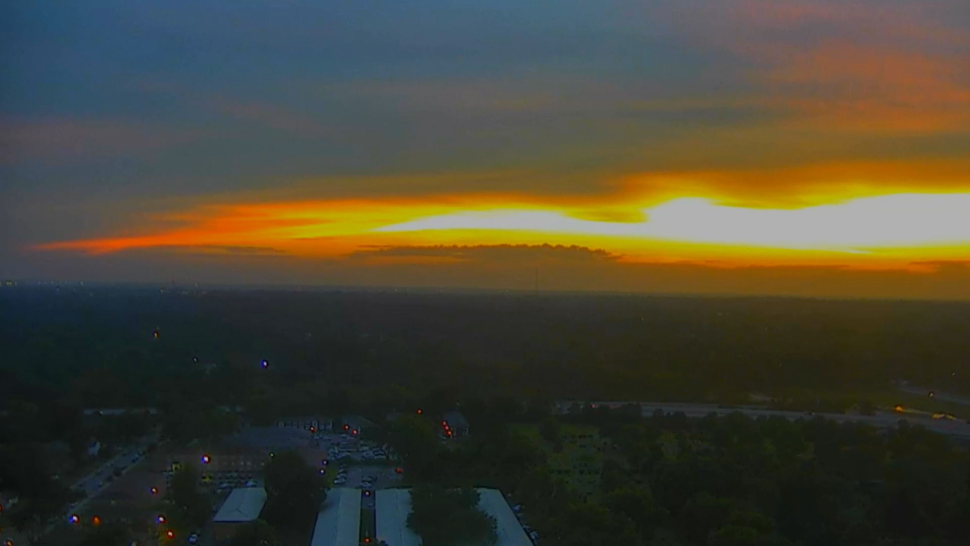
We have a bit of a light breeze still, which we need, and temps in the middle 70s!

Weather looks on track, with little to no changes expected before the fireworks show at 10pm.
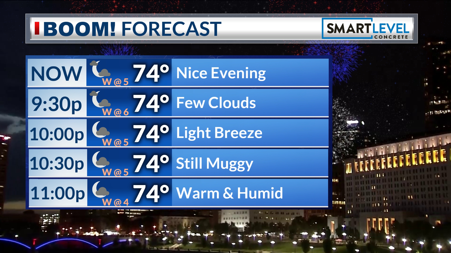
Have fun everyone and enjoy the show (live or on NBC4).
I am excited to watch!
-Dave
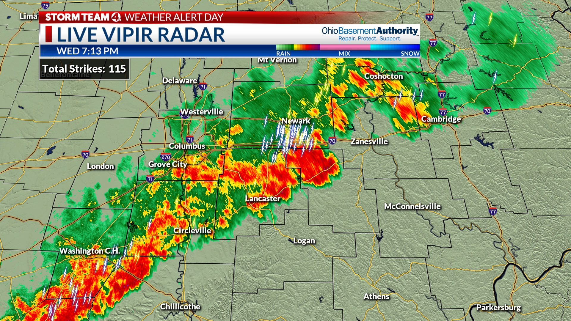
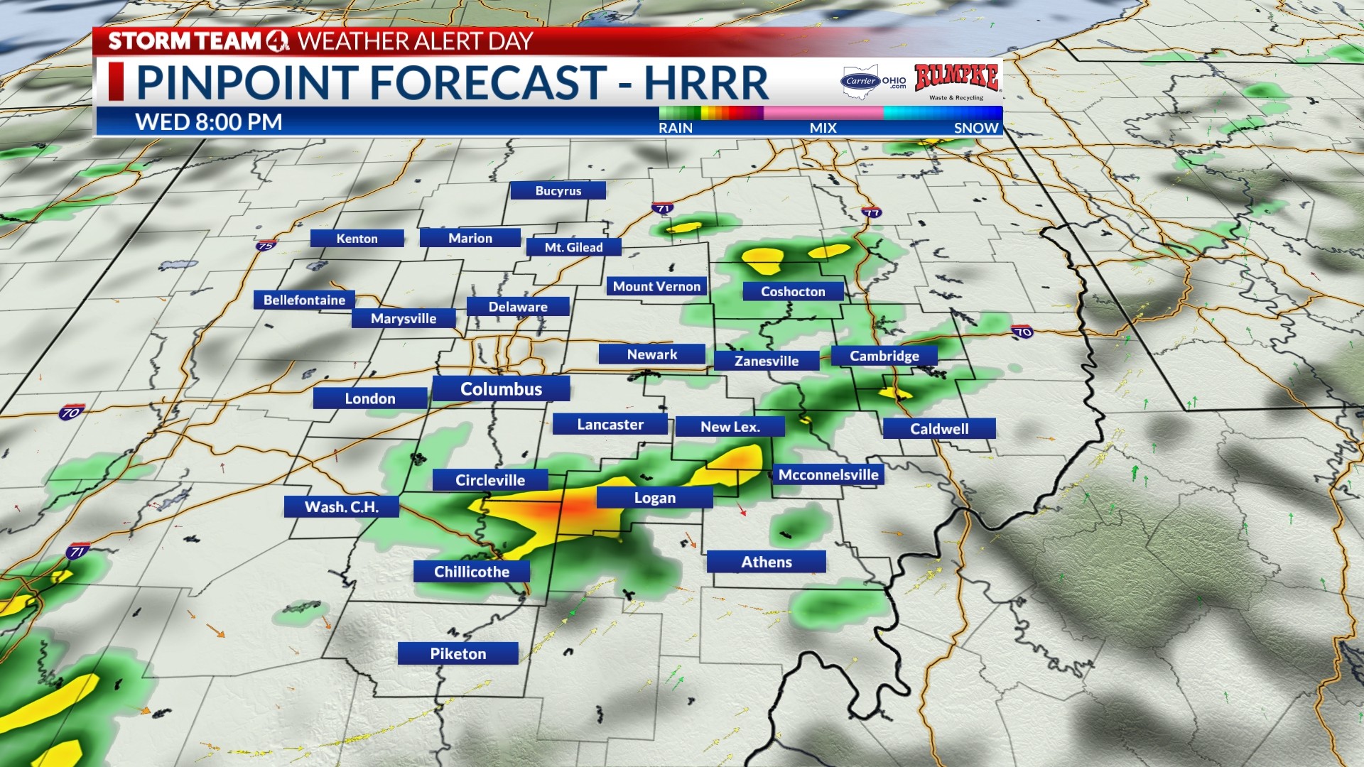
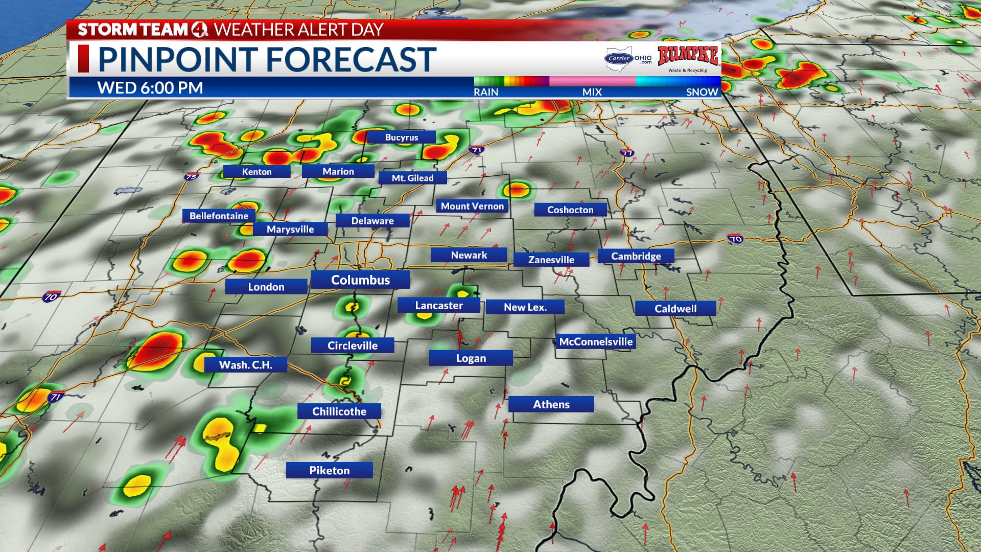
Rain exiting, lightning a bit slower to move out…
Hi all,
If you are downtown, you know, things are getting better rain-wise. We still have some lingering light showers in Franklin county.
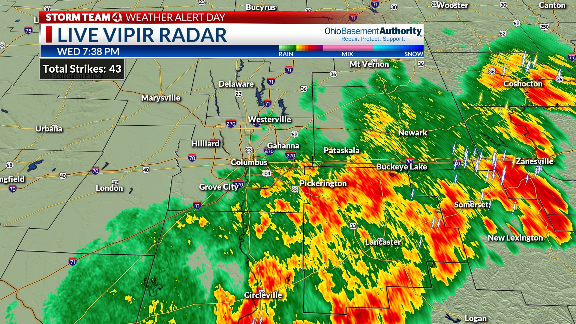
The big question mark is how much longer will it take til the last lightning strike is far enough away? We have had one lingering thunderstorms that was near Obetz ~715p, near Groveport @ 730p, & near Pickerington at 735p. It is almost 15mi from downtown right now.
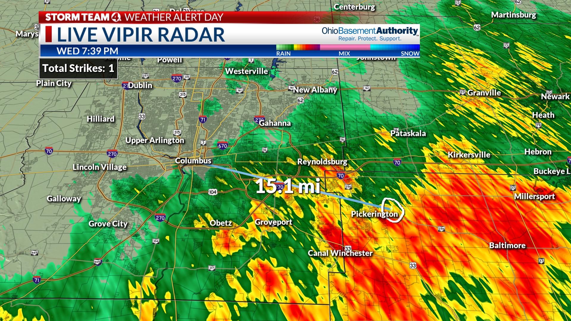
Behind that, the sunshine is actually returning to our west!!!! Here is the last thing to contend with…we need some wind now to blow the fireworks smoke away. We will monitor that.
-Dave
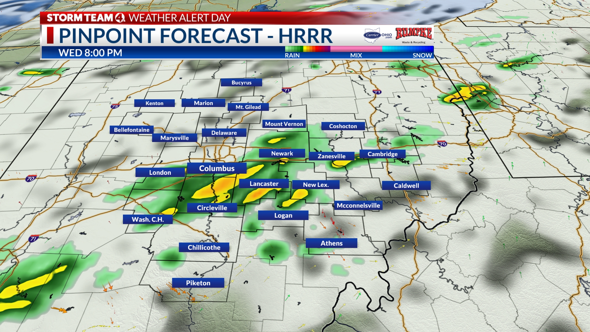
Fireworks are getting closer!
From Meteorologist Ben Gelber
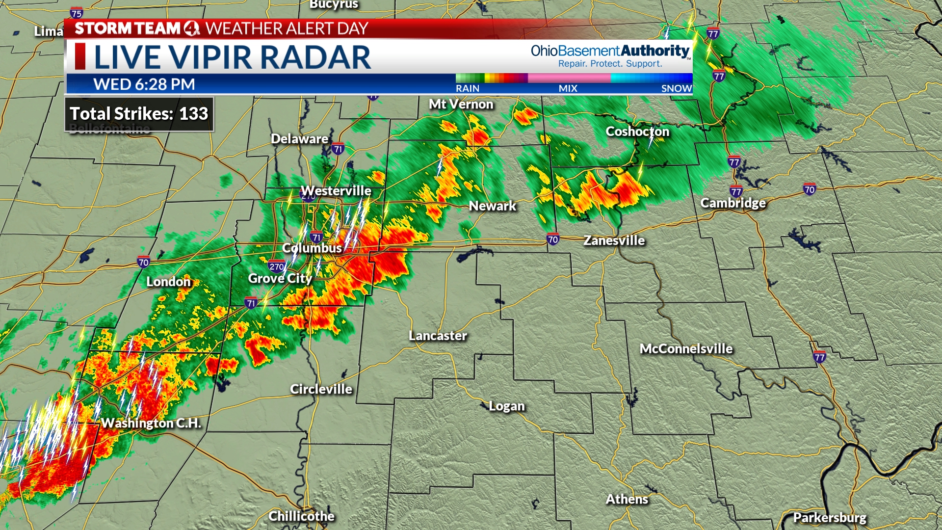
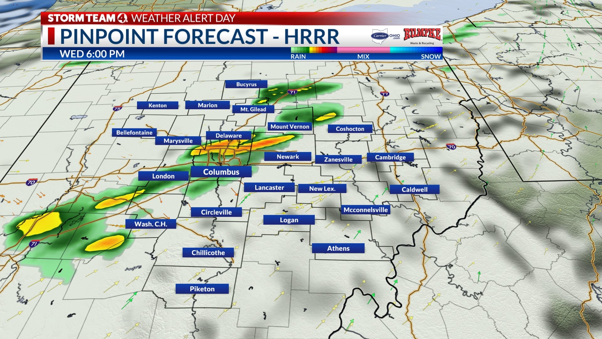
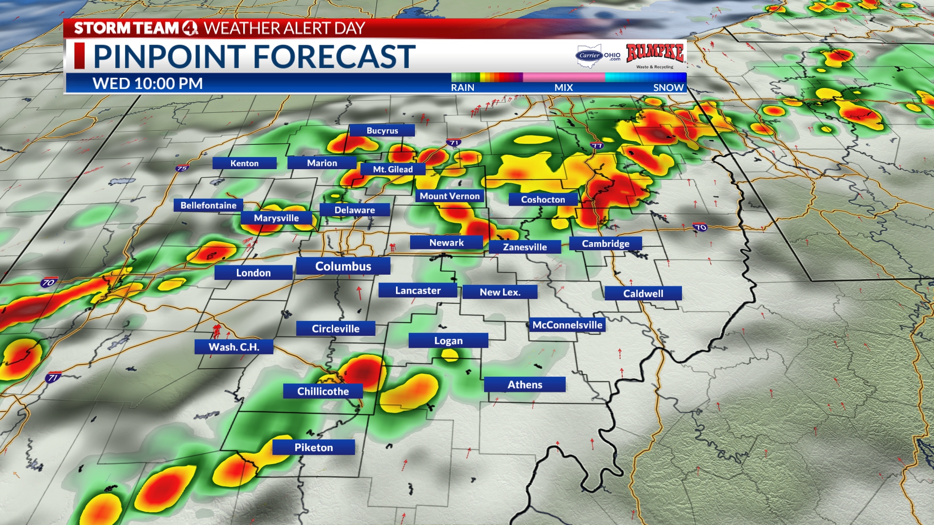
A long line of showers and storms extends from Cambridge to Columbus to Washington Court House. There is still some lightning in southern Franklin County within 5-10 miles of Downtown.
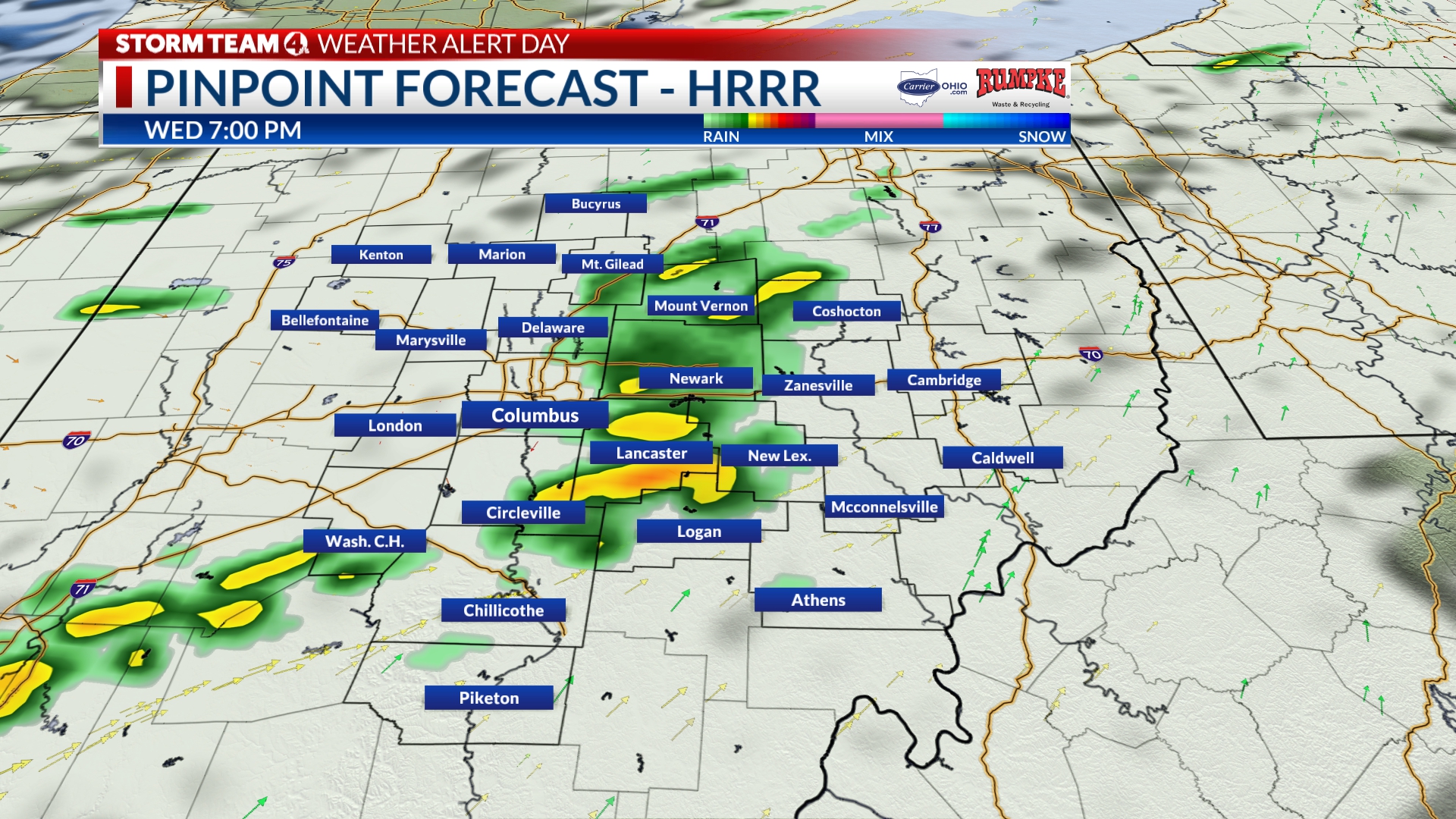
The good news is that the whole line will push off to the east after 8 p.m. in Columbus.
Strong storms are currently affecting areas south of Newark and approaching Chillicothe from the west, pushing east-southeast.
Most of the rain will taper off Downtown between 8-8:30 p.m.
Only 3 1/2 Hours Until The Fireworks!
Good Evening,
A line of showers and storms aligned with I-71 continues to slide east-southeast with pockets of heavy rain and frequent lightning.
The good news is that the rain and embedded storms will diminish to lighter showers after 7 p.m., although light rain could linger for another hour or so as the system sags south.
Temperatures have cooled into the 70s from the low 90s, although the humidity will remain high this evening. We will continue to update throughout the evening, but the threat of severe weather is over for the Columbus area.
Strong storms are still a concern for southern Ohio until sunset, where frequent lightning and downpours are possible.
From Meteorologist Ben Gelber
Tracking a line of showers and storms with heavy downpours moving into Columbus, which will be with us for the next hour.
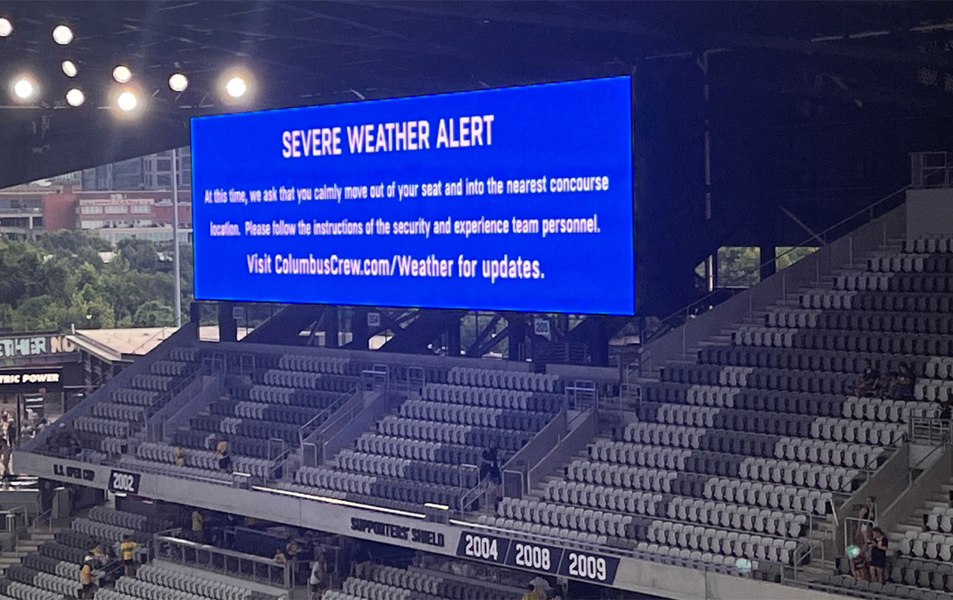
The Columbus Crew is scheduled to play Nashville SC at 7:30 p.m. at Lower.com Field. At 5:36, the team advised fans already in the stadium to move to the concourse area as rain and storms moved in. The image below came from NBC4 Digital Sports Reporter David DeGuzman.
Only 5 hours until the fireworks!
Good Evening! Meteorologist Ben Gelber here.
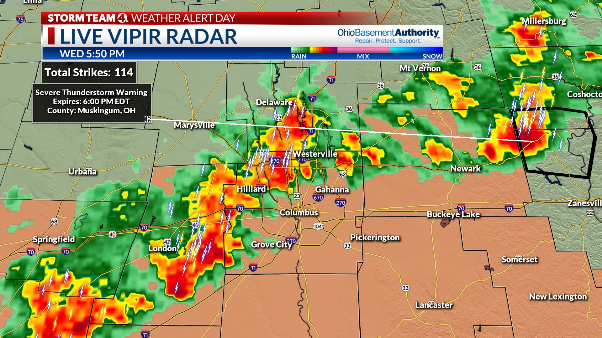
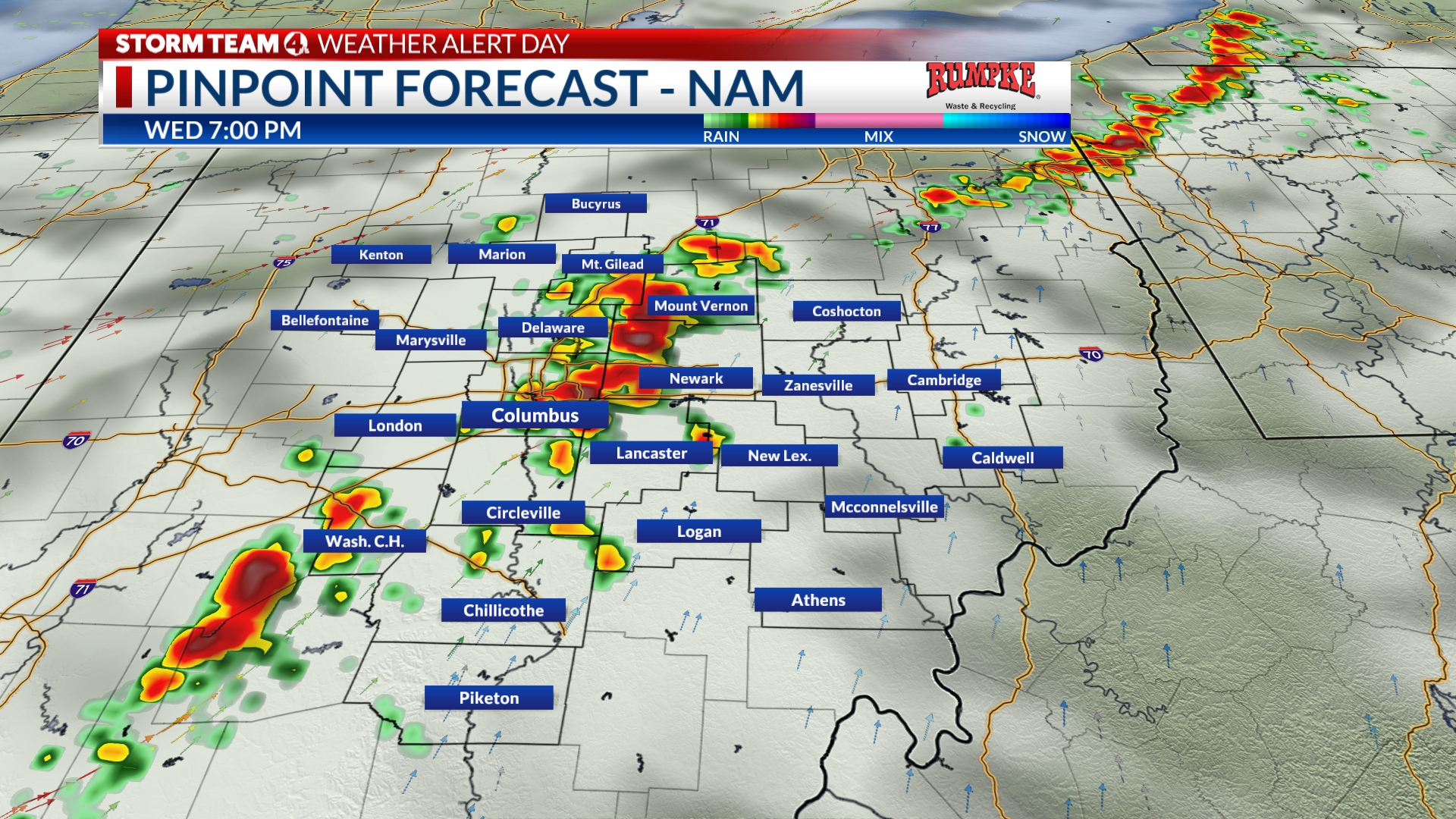
A line of showers and storms, with pockets of heavy rain and frequent lightning, is closing in on the city from the northwest, stretching from Newark to London, moving east at 35 mph.
A Severe Thunderstorm Warning is in effect for Muskingum and Coshocton County until 6 p.m.
Very heavy rain and gusty winds will accompany the passage of this line that will approach Downtown within the hour.
Be prepared to move indoors to avoid the danger of lightning. To be safe, you should hold off driving into this area of rain and storms, since it will begin to move off to the east after an hour or so.
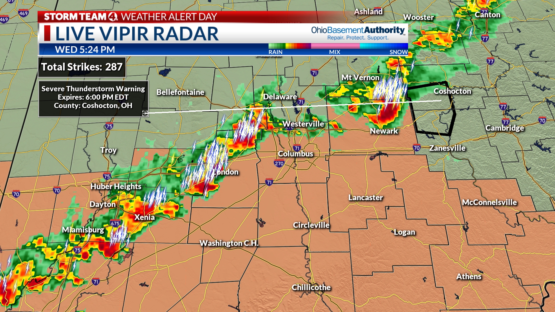
The greatest concern if you are under one of these storms is frequent lightning and very heavy rain.
Have a plan! Where will you go if thunder roars? Keep the Storm Team 4 Weather App handy. The better news is that, it does appear this line will move through, and should hopefully exit quick enough to get the fireworks show off on time tonight 🙂
We will continue to update throughout the evening, including for any thunderstorm watches or warnings.
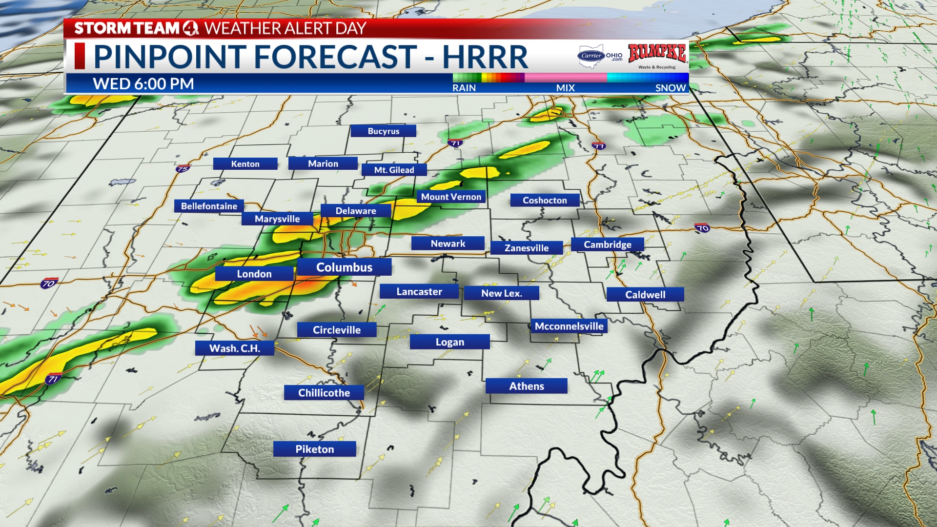
Only 6 Hours Until The Fireworks
Good Afternoon! Meteorologist Ben Gelber here.
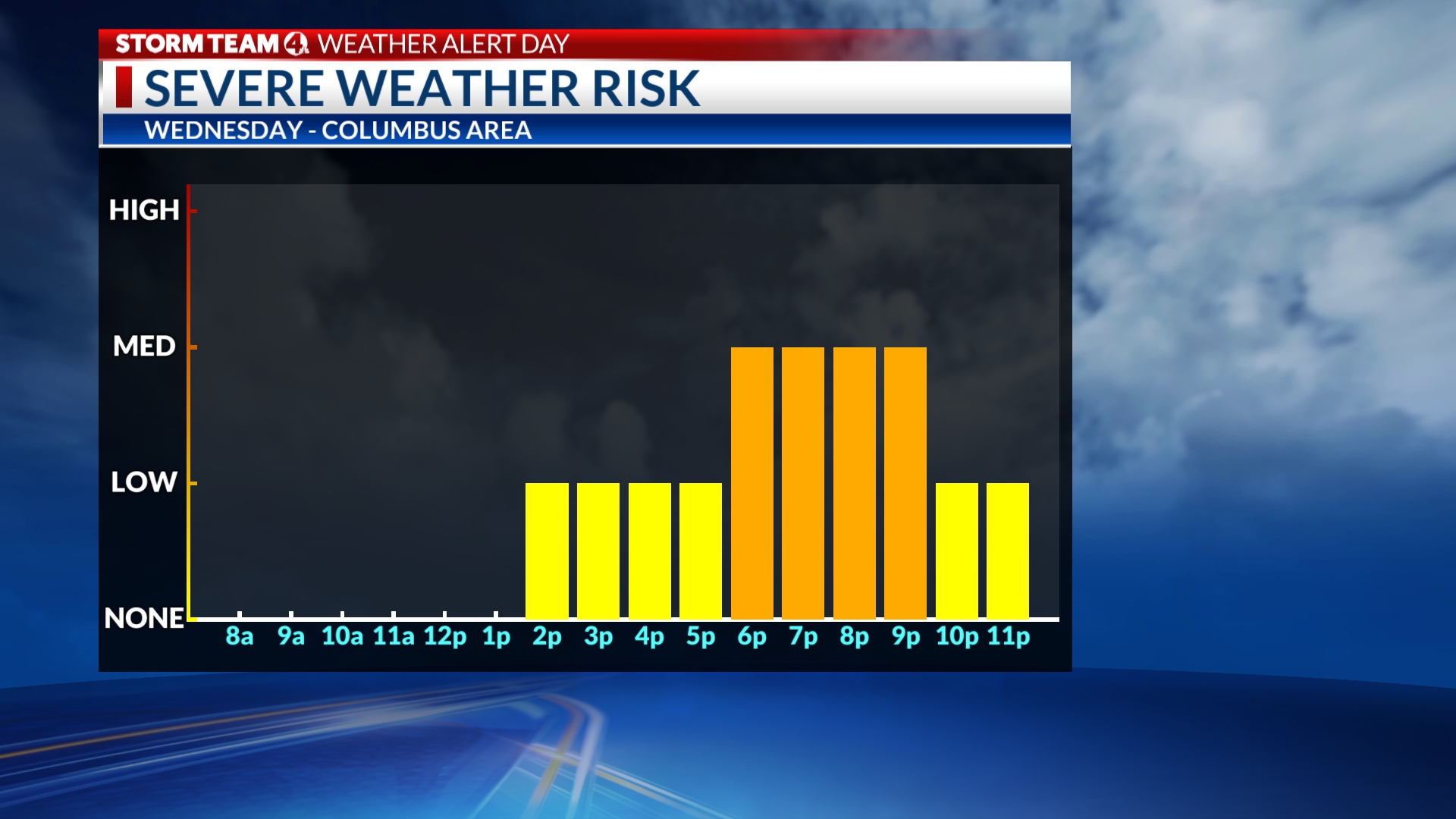
We are currently monitoring a line of showers and some strong storms aligned from Mount Vernon to a little north of Powell, moving eastward. Temperatures are in the low 90s, with a heat index in the upper 90s.
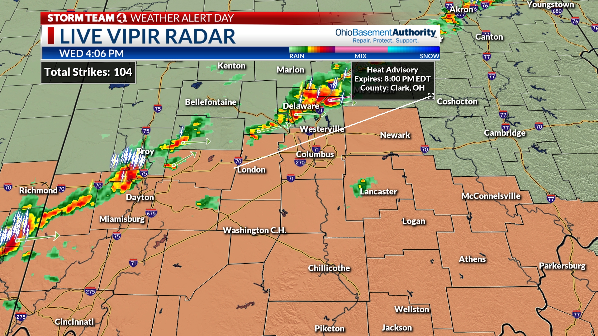
The line will slowly progress into the metro area. Initially, the strongest storms will stay north of I-270 on the north side of Columbus, but we are keeping a close eye on a cluster of storms between Troy and Dayton that will likely impact parts of the Columbus area between 6-8 p.m., with residual showers and storms pushing off after 9 p.m.
The greatest concern if you are under one of these storms is frequent lightning and very heavy rain. The line is not solid, so we’ll have to monitor the progress of the storms through early evening.
Have a plan! Where will you go if thunder roars? Keep the Storm Team 4 Weather App handy. The better news is that, it does appear this line will move through, and should hopefully exit quick enough to get the fireworks show off on time tonight 🙂
We will continue to update throughout the evening, including for any thunderstorm watches or warnings.
Only 7 hours til the Fireworks
Good afternoon everyone!
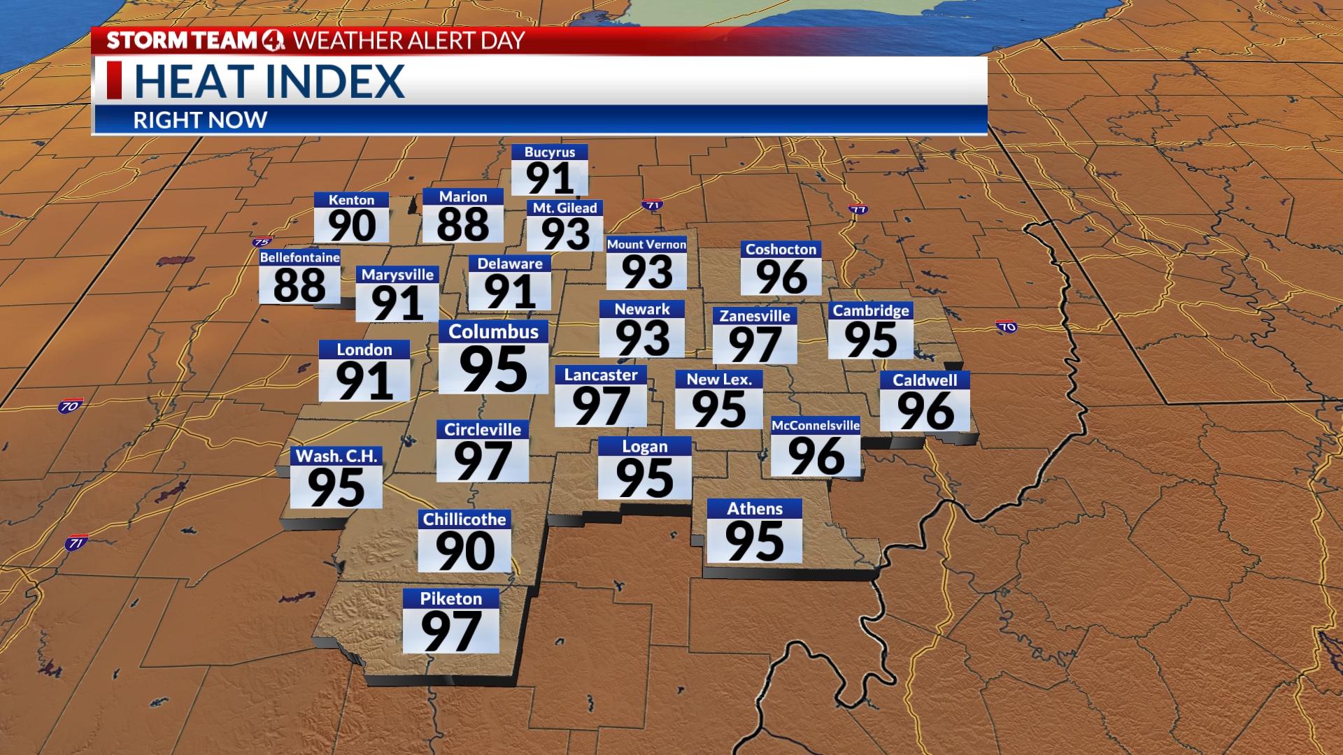
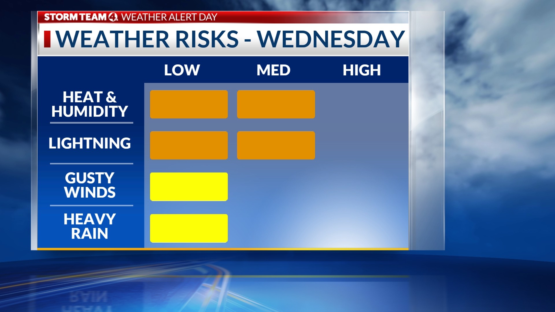
Is it hot enough for you yet?!? Heat advisories continue until just before sunset, with the likelihood that mid 90s to near triple digit heat index values will last only a few more hours, if that.
Rain and storms are starting to pop to our west, and this line has storms moving to the northeast along the line. The line itself is approaching our area, and should be in between about 530p-9p around the Columbus metro.
The thinking is these showers will become more thunderstorm activity as the afternoon progresses and they arrive into the city. The main threats will be lightning (as being outside in a thunderstorm is not great), but we could see some strong gusty winds in some of the stronger storms, and brief heavy rains as well.
As we mentioned yesterday & all day today, just have a plan! Where will you go if thunder roars? Keep the Storm Team 4 weather app handy too! The better news is that, it does appear this line will move through, and should hopefully exit quick enough to get the fireworks show off on time tonight 🙂
We will continue to update throughout the afternoon/evening as this line progresses, and if any thunderstorm watches/warnings will be issued!
-Dave
Showers starting to move into Central Ohio, when to expect the rest
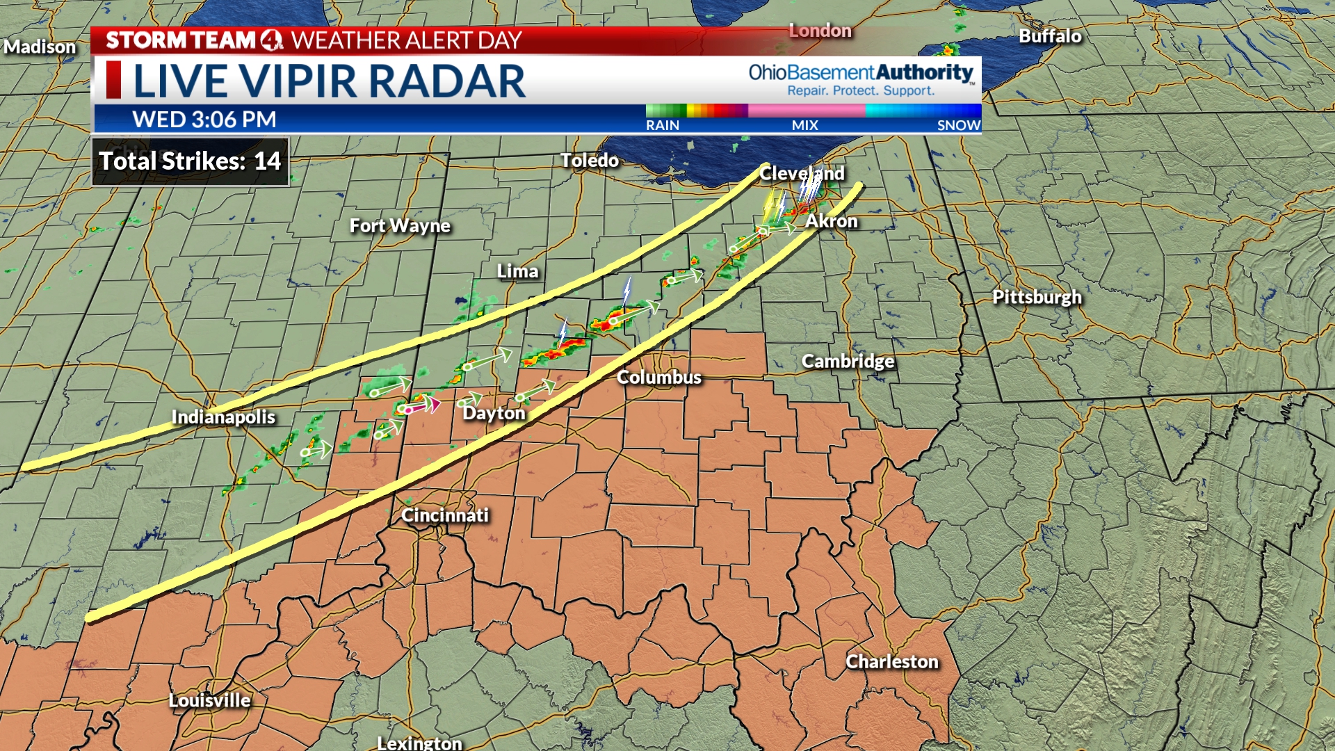
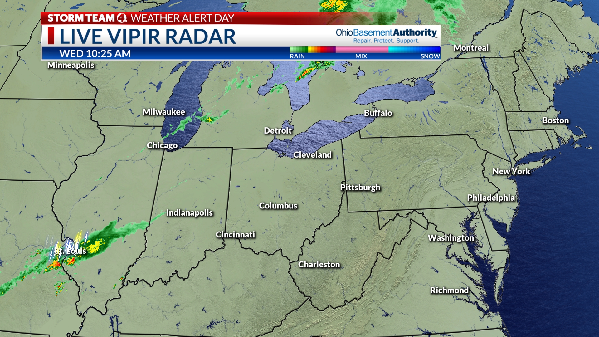
New scans of LIVE VIPIR RADAR are showing a few showers starting to push into our western counties.
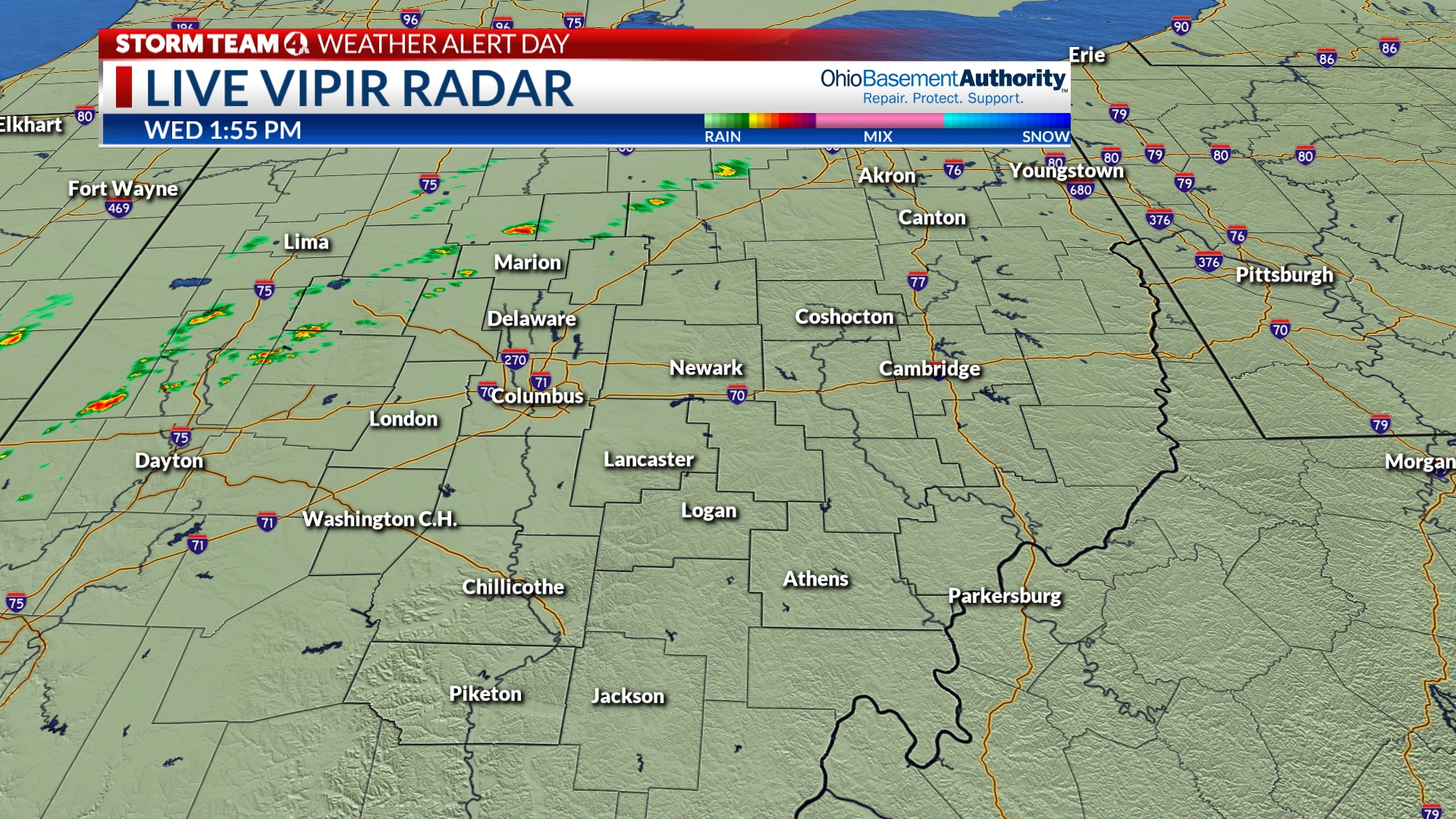
The line of showers is starting to shape up as the cold front has started pushing into Ohio. As of 2 PM, there isn’t any lightning associated with these clusters quite yet.
Models are showing a gradual slowing of the front when it moves through, but by a very small amount. Still between 5-7 PM, the line will move through the metro area. Both modelling and the SPC agree that this line will stay fairly broken and unorganized.
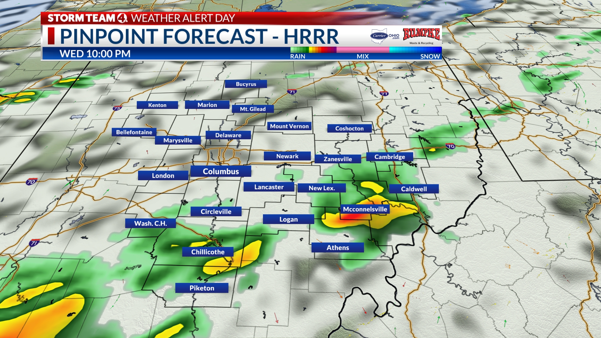
Still, by 8-9 PM, the line will be starting to leave the metro area. The line starts to break up a little more and turn scattered to isolated at this point. There will still be showers to the east and south, but the metro area will begin to get drier.
Closer to 10 PM, the skies will start to be a little calmer around downtown Columbus. The High Rapid Resolution Refresh (HRRR) model still brings in a few showers past midnight, but those will likely be nothing other than rain.
Even with the relatively disorganized structure of this incoming round of rain, these storms still have the potential to develop into stronger ones and bring in some strong winds.
There hasn’t been any change with our severe weather outlook. Especially as we head closer to the evening hours, be sure to be weather aware. Have a way to get alerts (like the Storm Team 4 weather app) and if thunder roars, go indoors!
-Joe
Latest discussion from the Storm Prediction Center
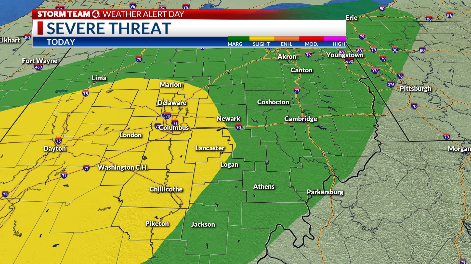
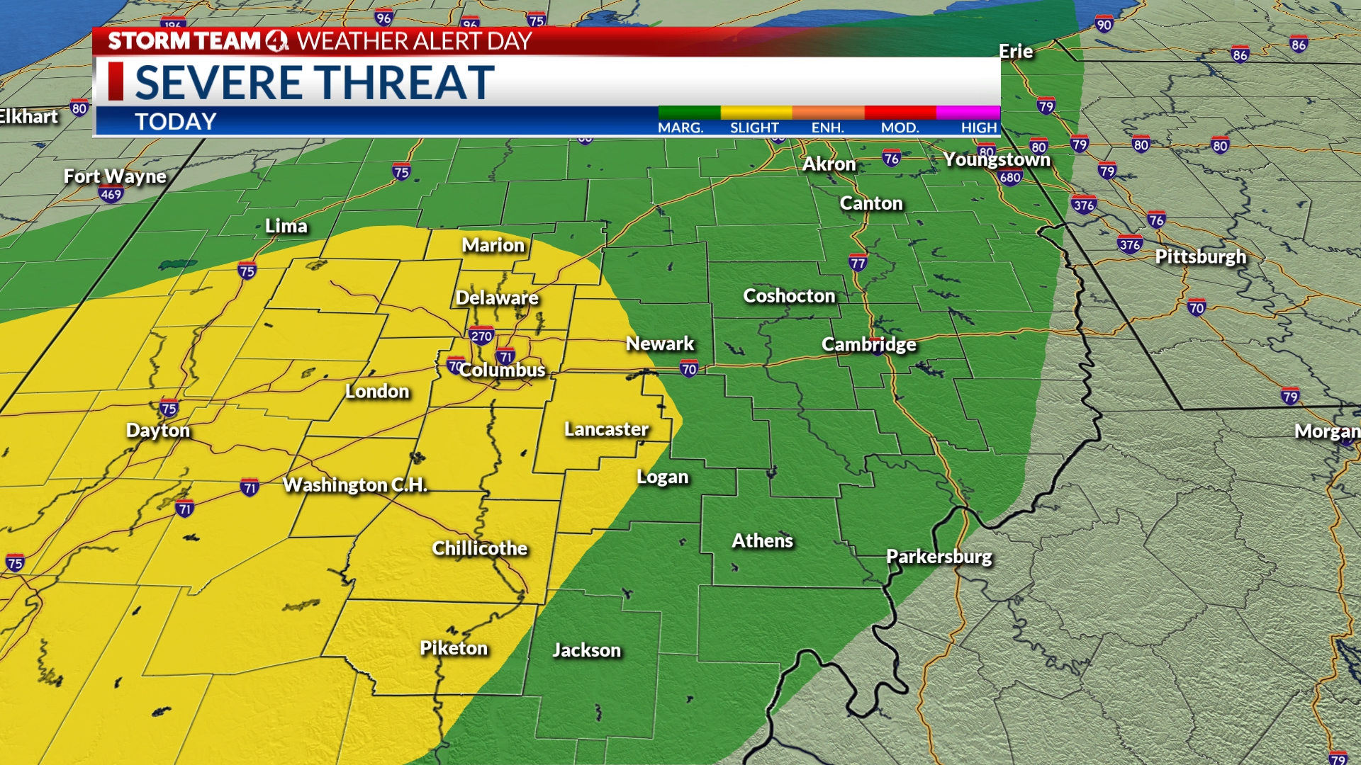
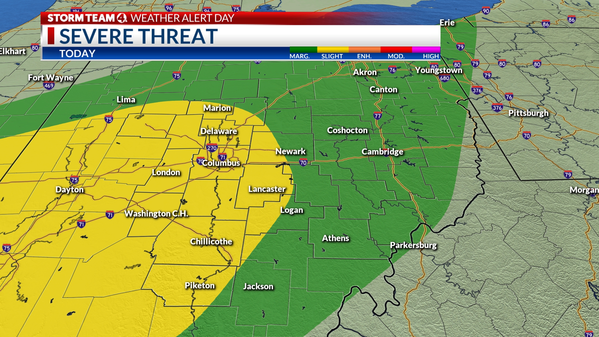
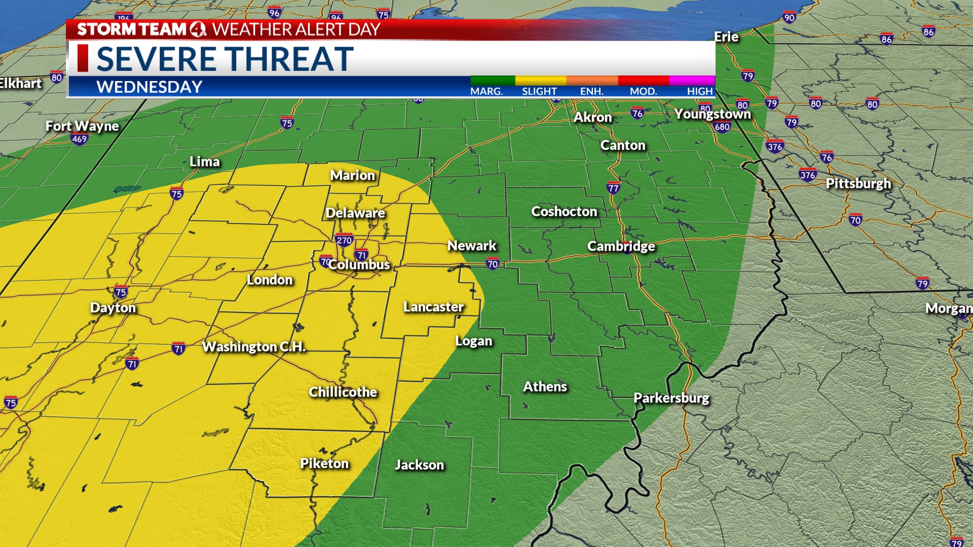
The outlook for Central Ohio still remains at a slight risk for areas around Columbus and southwest along I-71. The rest of us are at a 1/5, or marginal, risk for strong to severe storms.
The Storm Prediction Center, responsible for creating those severe outlooks, has released an update on their thinking as we get closer to 1 PM. There is still the concern to see scattered thunderstorms that could produce strong to damaging wind gusts and frequent lightning.
As it stands, of the three major severe weather risks, damaging winds remains as the primary threat. But, that’s not to say that the other two (hail & tornadoes) are completely ruled out. Given the nature of the system, the other two are just unlikely.
The nature of the incoming line of storms could play into our favor. With the line looking fairly unorganized and broken, it could spare us from a more widespread chance of storms. With that said, even disorganized showers can develop into strong ones and produce powerful winds.
With Storm Team 4 declaring a Weather Alert Day, make sure you have ways to know what storms are heading your way. Red, White, & BOOM! will still be a day to enjoy, but just know what your plan is if a thunderstorm develops.
-Joe
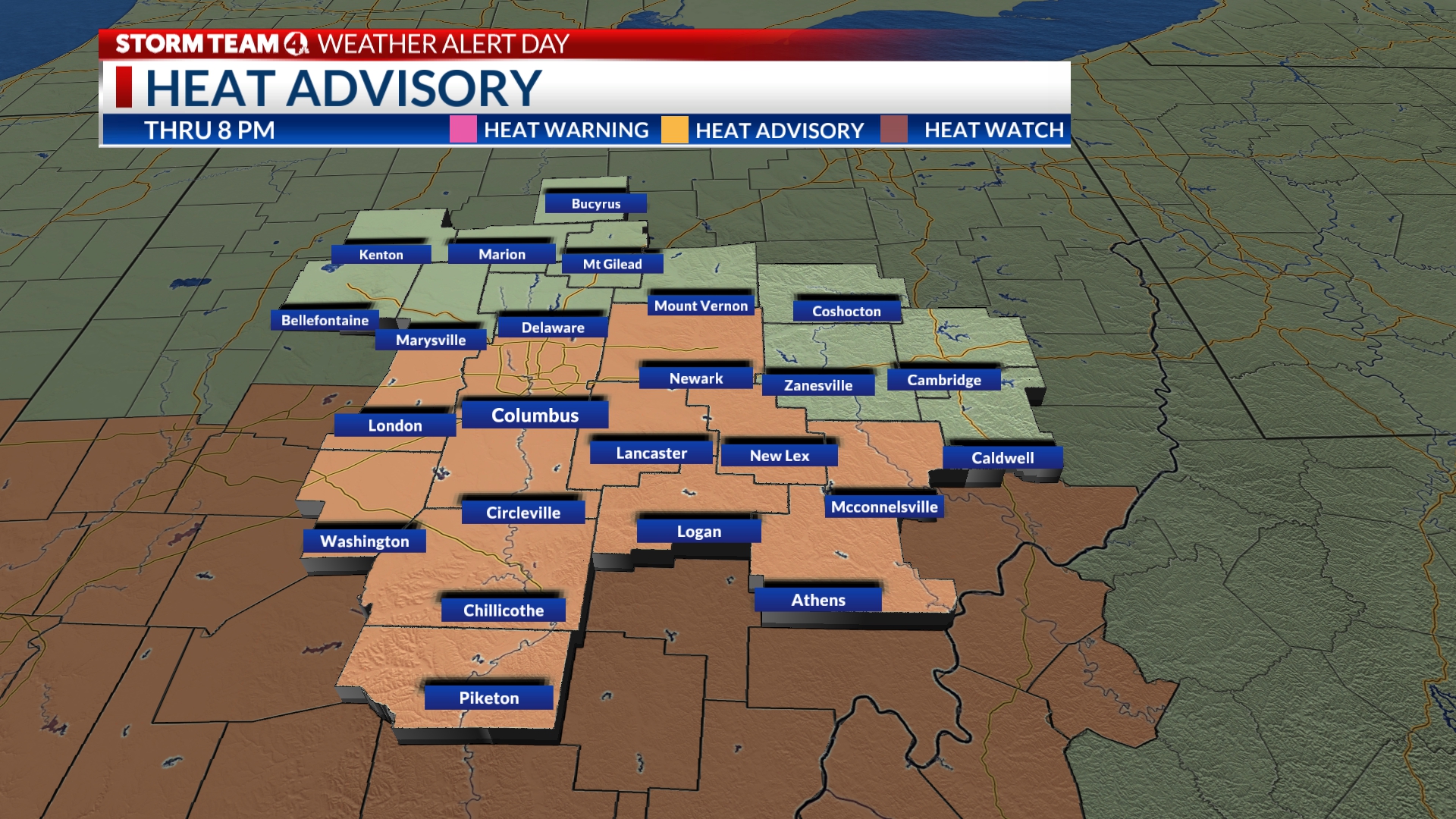
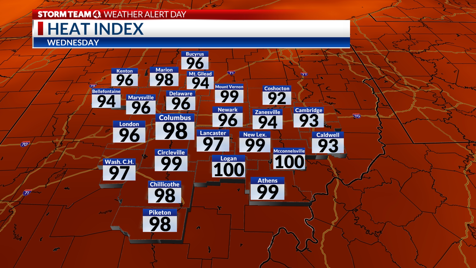
Heat Advisory officially in effect, it’s going to feel hot!
As the clock struck noon today, a Heat Advisory *officially* went into effect for parts of Central Ohio. Franklin County, Licking County, and areas south of I-70 will remain under that advisory until 8 PM tonight.
Temperatures are getting a big bump going into today compared to the start of the week. The thermometer will climb into the mid to lower 90s. At the same time, humidity is building. Dewpoints have pushed into the lower 70s, meaning the air will feel pretty heavy outside and it’ll feel a decent bit warmer than the actual temperature.
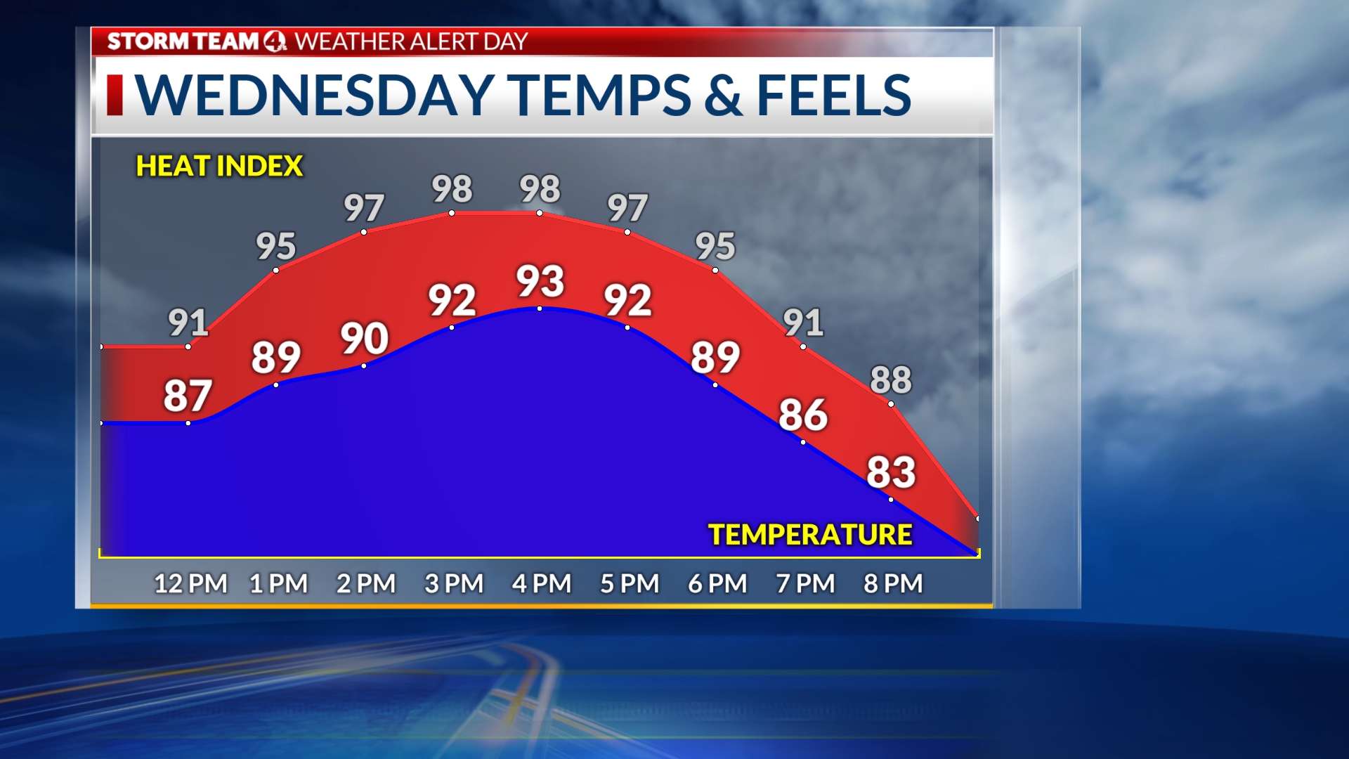
Observations have shown a pretty steady increase in the distance between the temperature and heat index. Around 8 AM, there was less than a 2 degree difference, meaning we weren’t feeling to far off from the temperature. By 10 AM, there was a 4 degree difference. At noon there was a 6 degree difference.
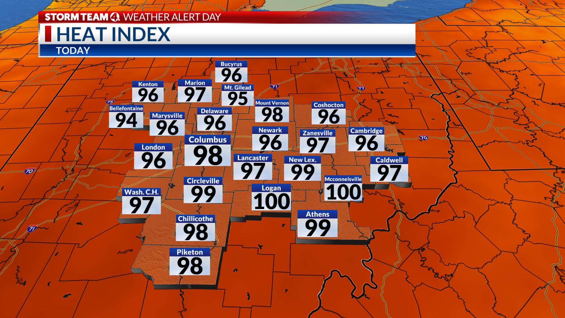
Heat index values are expected to build close to triple digits today. Be sure to hydrate if you’re heading out! Know your limits and try to lower your heat exposure if you can!
-Joe
Breakdown of severe weather risks, what to expect
Parts of Central Ohio are still under a slight risk of seeing severe weather. That includes the majority of the metro area. Farther to the southwest, mainly along I-71, that 2/5 risk continues. The remainder of our area is at a 1/5, or marginal, risk.
The primary timing for today’s storms still sticks with the late afternoon and evening hours. Storms remain fairly scattered, so there is no organized/widespread risk. The main risk factor with these storms will be lightning and strong to damaging winds.
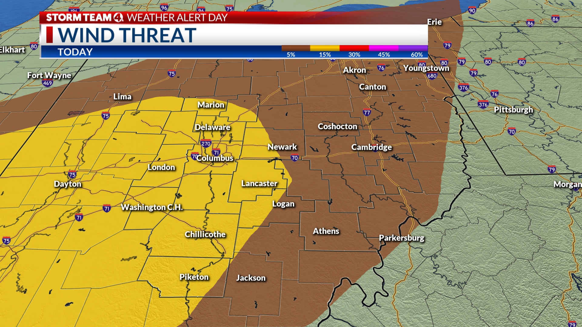
In the same areas that are under a slight risk for severe weather, there is a low to moderate risk of seeing the stronger winds. That threat is a little lighter for places in the marginal risk.
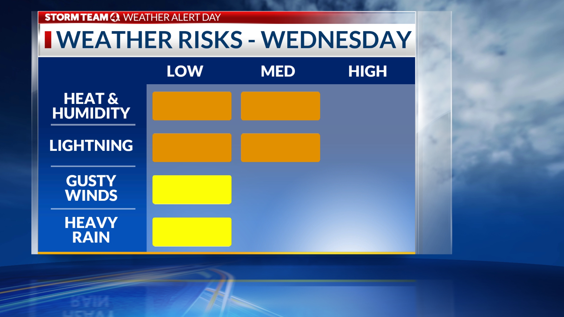
Aside from the storms, today is also a Weather Alert Day due to the sharp increase in heat & humidity. Temperatures are expected to climb into the low 90s today with heat index values approaching triple digits.
Even with the risk for unpleasant weather, you can still be outside and enjoy Red, White, & BOOM! Download the Storm Team 4 weather app to get alerts straight to your phone so you can be prepared for today!
-Joe
Latest modeling & timing on todays storms
Central Ohio is still in line to see storms & showers move in as a cold front sweeps into the state. As of 10:24 AM, the line remains far off to our west and appears fairly unorganized.
Two short-range models have finished outputting their latest round of data. Both the NAM & HRRR keep the first, main line arriving into Central Ohio closer to 4-5 PM. Storms & showers will remain fairly scattered as they push farther south and east. By 9 PM, both models push the bulk of our heaviest rain out of the area.
There is still the chance that we could see a few scattered showers past midnight, potentially adding more rain for the drive home tonight. But, those storms will likely carry little potential to be severe.
The chance for severe weather still remains at a 2/5 risk for Columbus and areas south along I-71. The rest of Central Ohio remains at a 1/5 risk.
Thankfully, severe weather risks don’t look widespread. So, there is still ample opportunity to enjoy the day, but still be weather aware.
-Joe
Steps to keep yourself safe during a thunderstorm
As mentioned in the blog below, Central Ohio has the threat for strong storms late-afternoon/evening today.

With a lot of people planning to spend time outdoors, I figured I’d walk you through best precautionary steps to take should you find yourself outside at BOOM!, or anywhere else during a thunderstorm.
The best place to shelter is always in an enclosed building, but if you do get caught in a storm downtown, head back to your car and shelter there until 30 minutes after the last clap of thunder.
Additionally, you may want to take an outdoor blanket with you to BOOM! These storms will have the potential to drop heavy rain in a short period of time, wherever they set up. So to avoid wet pockets when you sit for the fireworks, a blanket would be a good idea.
Again, Storm Team 4 will continue to monitor this, as storms look to be scattered, not widespread. It is a day to remain weather aware.
-McKenna
Slight risk for strong-severe storms
The Storm Prediction Center keeps Columbus and areas southwest under a “slight” 2-out-of-5 risk for strong to severe thunderstorms.
The threat is for late-afternoon/evening as instability builds thanks to high heat and humidity. This is for scattered strong storms, not widespread. It’s something Storm Team 4 will be keeping a close eye on all evening, as we continue updating this weather blog.
Primarily we’ll be watching for a damaging wind threat, and also for localized heavy rainfall within thunderstorm cells.
Stay safe and stay weather aware with the Storm Team 4 mobile weather app!
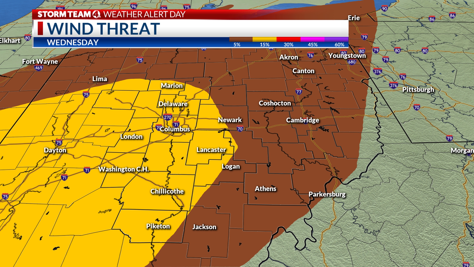
A breezy afternoon, but winds die down tonight!
In addition to all the other weather headlines we have today (see below!), it will be a breezy afternoon, with sustained winds 10-15 MPH, and gusts a bit higher.
Obviously for fireworks to go off, it can’t be too breezy. And I have good news on that front! While the afternoon will be a breezy one, winds do look to die down as we get toward the 10 PM hour, with sustained winds closer to the 5-10 MPH range.
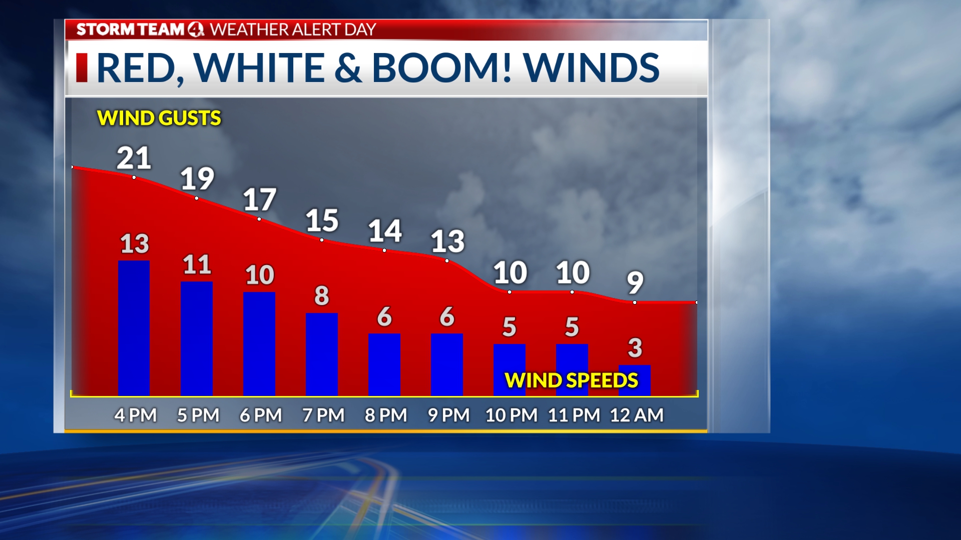
This would be a perfect wind to blow the smoke away from the fireworks, and give a nice, clear view.
Of course, winds can get much higher inside thunderstorm cells, so as we’ve mentioned, we will be keeping a close eye on where each storm cell sets up.
-McKenna
Tips to beat the heat for BOOM!
We’ve got a Heat Advisory that takes effect at noon today, and lasts through 8 PM. This is for “feels-like” temps approaching the triple digits as a result of high heat and high humidity.

So what are the best ways to beat the heat!?
1. HYDRATE!! This will be key. Start hydrating in the morning, and make sure you’re drinking lots of water.
2. Wear lightweight, loose-fitting clothing.
3. Wear lighter colors. This will help keep you cooler, as lighter colors don’t absorb as much sunlight.
4. Take breaks in the shade. Find a real nice tree, and settle in under it periodically through the afternoon.
Have fun, and stay safe!
-McKenna
High heat, storms later… Stay weather aware for Red, White & BOOM!
Good morning, and happy Red, White & BOOM! day!
You’ll likely notice the increased humidity as you step out… we’ve got a muggy day ahead! As a result, a Heat Advisory takes effect at 12 PM and lasts through the afternoon and evening. This is for “feels-like” temps approaching the triple digits.
Stay hydrated, and wear light and loose fitting clothing. Find a nice tree, and take breaks in the shade.
As we get into the late-afternoon/evening, scattered storms start to roll in.
Storm Team 4 will be monitoring this closely, as it will be strongly dependent on where each individual storm sets up.
Download the Storm Team 4 mobile weather app, and you’ll be able to stay weather aware there.
Enjoy BOOM!
-McKenna
Good Morning & Happy Red, White, & Boom Wednesday!
Good Morning Everyone! I hope everyone is ready for what hopefully will be a fun day later. Storm Team 4 will be updating this very often throughout the day, so make sure to check back in with us frequently. If you are going out to BOOM! Make sure you download our FREE Storm Team 4 Weather app (links provided below)
We will be broadcasting all our newscasts here on nbc4i.com live throughout the day, and providing many updates.
Ok, now to the weather stuff….
Look, we have a front heading our way, it definitely packed a punch across Iowa, Missouri, and parts of Kansas/Illinois on Tuesday evening. We will be watching that same boundary pushing into our area late in the day today.
The Storm Prediction Center has most of our area under a “slight risk” level 2/5 for severe storms later today/this evening.
This will likely be slightly modified through the day as the weather plays out during the day. Heat/humidity, and a surge of additional moisture should feed into our area, and provide ingredients for storms later.
Because of the timing of these storms, I think the main threats are going to be strong gusty winds with the worst storms, lightning (with any storms, def an issue if you are outdoors), and possibly some heavy rains in our soupy airmass.
Bottom line: Be prepared on what you and your family will do if you are out waiting for the fireworks & having a good time today, and hear thunder roar.
Will you have a way to get weather alerts? (Our weather app can do that)
Will you have a way to get alerted for lightning nearby? (Our weather app does that too)
Do you know where you will go to seek shelter?
The last question is up to you. I am a dad, we have lots of outside sports, we do outdoor activities too, and I often think of where we can go if the weather is semi-questionable. Think about how you got down to RWB… maybe head back to your car, if we do have some storms nearby. Or an inside location nearby. Our goal is to make sure everyone is prepared in the event we do have weather to contend with. We can’t change it, we can only prepare and plan around it.
Everyone wants to have a fun, safe, and happy Red, White, and Boom! Storm Team 4 will continue to update you about the possible incoming weather so you can be prepared for anything!
Don’t forget plenty of water, sunscreen, and a plan.
Happy Boom Wednesday 