COLUMBUS (WCMH) — Here is it early August, and we are already thinking about snowfall in Central Ohio. Yes, it is still far away, but we are already getting questions about snowfall forecasts for this upcoming Winter.
I am a stats geek, and love doing research on stuff, so I put my nerd skills together and came up with my “way too early forecast” for this upcoming Winter season (Winter 2016-17).
First, it is important to note that we are coming out of a Very Strong El Nino. The latest forecast from the Climate Prediction Center at NOAA is a 55-60% chance of a weak La Nina to form during the Fall and Winter of 2016-2017.
So what does that mean for us?
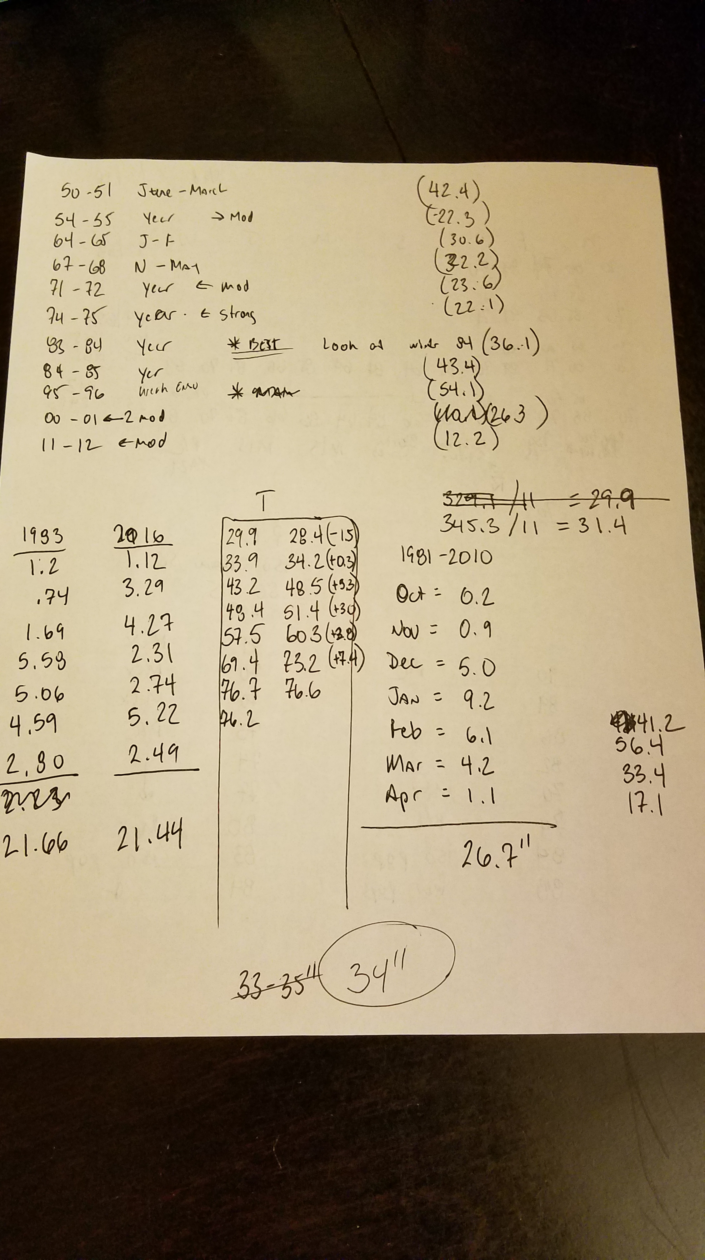
I looked at the data from 1950-2016, and there were 11 seasons that experienced a “weak La Nina” as forecast for this upcoming season.
Below is the snowfall totals for each of those seasons:
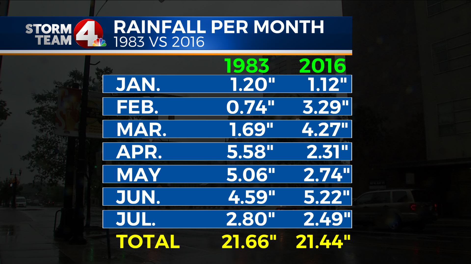
Our 30 year snowfall normal for Columbus is 26.7″ of snow
- Oct. 0.2″
- Nov. 0.9″
- Dec. 5.0″
- Jan. 9.2″
- Feb. 6.1″
- Mar. 4.2″
- Apr. 1.1″
The 11 season average during the “weak La Nina” was above the 30 year normal, at 31.4″. However, you notice there is quite a spread. Our last “weak La Nina” had just more than 1 foot of snow for the season, but when you go back to the mid 90s, we had roughly 4.5 feet of snow.
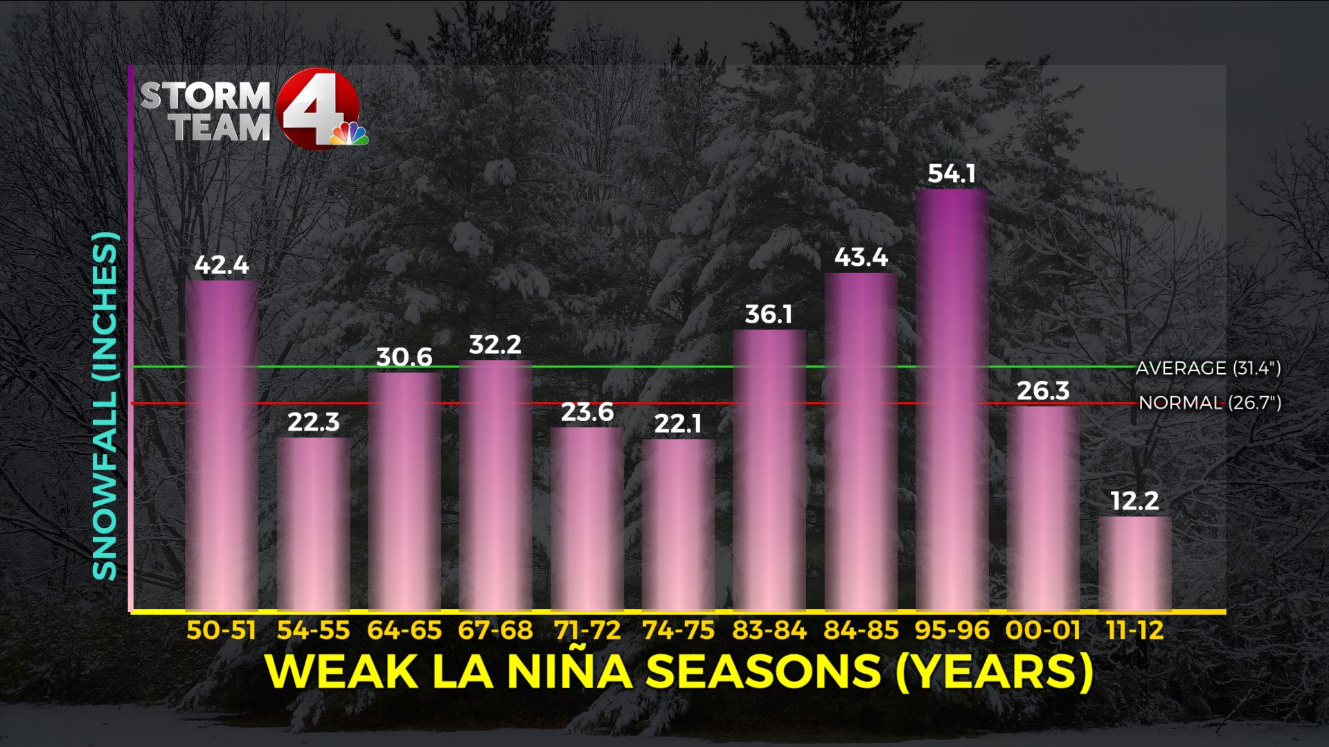
So next, I decided to dig deeper into the data, to see if I could find another season that looked somewhat like this season. Some of the La Nina events followed moderate El Nino events, some were strong, and then other weak La Nina events followed other La Nina events. There was one set that stood out in my mind, and it was the 1983-84 event. It was also a weak La Nina, and it followed an El Nino, and not just any El Nino, but a very strong El Nino. Right now, we just had our first 3 month period of near neutral conditions. This ended 15 consecutive 3 month periods of El Nino, the same as which occurred in 1982-1983. The time we came out of the El Nino were almost a month apart too in each year (August 1983, vs July 2016).
I actually decided to compare these years for fun on precipitation for the years through the first 7 months. Below you will see a compare of the two years…
… And surprise, they are almost the exact same! Both years were abnormally dry through the first 7 months of the year.
Temperature wise, the story was a bit different as 2016 has been a warmer year, much warmer in the Spring and early Summer. But, when it comes to July, the temperature difference was only 0.1 degrees for the entire month, while rainfall was less than a third of one inch different.
I took other things into consideration, including our abnormally dry period we have extended through our Summer this year, with more of our 21+” of rain occurring earlier in the year, and now we are into a drier pattern. Also, the fact we are experiencing warmer temperatures this year vs 33 years ago.
Plus I looked at long range outlooks for temperature and precipitation for the upcoming Winter Season.Bottom line:
I do not think we will see the 36.1″ total we had in the Winter of 1983-1984, but I think we will be close. In fact, my forecast number is a bit higher than our “weak” La Nina average of 31.4″ too.
Remember, our last 4 Winter snowfall totals have been
- 2015-16: 17.1″
- 2014-15: 33.4″
- 2013-14: 56.4″
- 2012-13: 41.2″
So for this upcoming Winter 2016-17 my forecast made in early August is below:
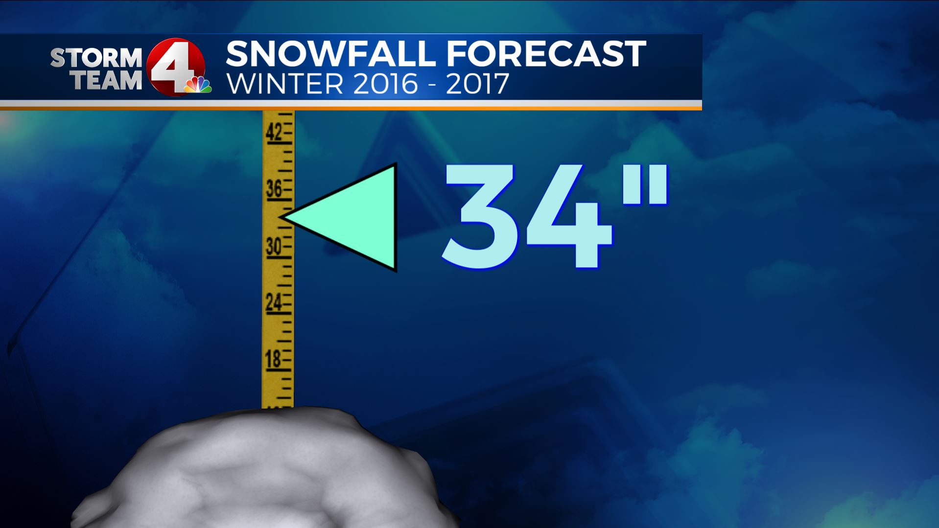
With a range of 12″ to 54″ history really left me with pretty much the biggest possible range as a guide, but who cares! That is why making a long term forecast is fun.
We always have a contest in the weather department for snowfall for the season, when we all have numbers we will have to update.
I am coming off my best seasonal forecast for last Winter, so I am feeling pretty confident! Now go out and enjoy the heat for the next 6 weeks, before you know it, Autumn will be here 🙂
Below are some of my “nerd notes”