Winter Weather Advisories & Warnings:
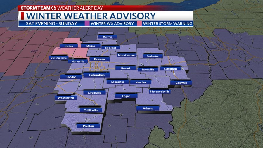
For Hardin, Logan, & Union counties, a winter storm warning is set to go into effect starting at 6 p.m. Saturday and going through 7 p.m. Sunday. During this time, the area will see heavy, wet snow through Sunday night.
The rest of central Ohio will be in a winter weather advisory. In areas like Franklin County, this is set to begin at 6 p.m. Saturday and continue through 1 p.m. Sunday. Snowfall will continue through mid-morning before changing to sleet and rain later.
Snow will overspread central Ohio from the southwest before midnight and accumulate 3 to 5 inches by mid-morning Sunday, before mixing with sleet and rain. Temperatures will edge into the mid-30s by afternoon, turning roads from very slippery to slushy.
In northern Ohio, snow will continue to accumulate with totals as high as 6 to 8 inches by Sunday night.
WHAT TO EXPECT:
Saturday night – Sunday morning:
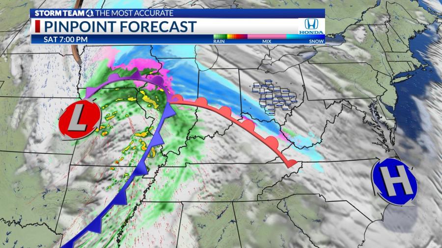
The system will move from the southwest into our area after sunset. By 7-9pm we will see light snow showers finally overcoming our drier air, and it will start to snow efficiently in the west and southwest part of the state.

By Saturday night before midnight, much of our area will see some accumulating snow, including in the south. The heaviest snowfall will occur in the northwest part of our area by this time.

Overnight into Sunday morning, we will have our best chance of seeing the highest snowfall totals. This is as we see the best moisture ahead of the low, and the colder air mixing in. This will give us at times moderate snowfall rates overnight.
This event will come in a few phases, the first phase will end around daybreak on Sunday as the warmer air starts to work up into our area as the low gets near. Through this time period, we will see several inches of snow in our area.
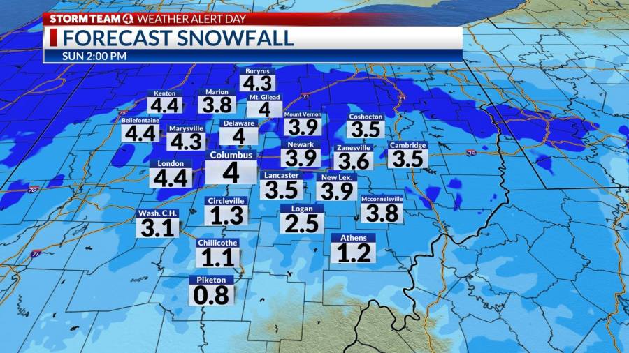
The snowfall totals above are just for the first phase of this storm, Saturday night through Sunday morning at 9am. At this point, “warmer air” (above freezing to near 40) will move into our area with rainfall.
SUNDAY LATE MORNING – MONDAY:

We will see the warmer air and rainfall starting to melt and tamp down some of that snow. At this point it appears this rain/snow line will lift as far north as about 40miles north of I-70, or just north of US-36. North of this area, the highest snow will stay on the ground as it will not melt much or have rain added to it.

By Sunday evening, the colder air will start to move back into our area, and this will change the precip back to wet snow mix and then snow overnight. Because we will start to the on the backside of the low, there will not be as moisture to work with, so snowfall rates will be much lower.

Overnight we will see an additional inch or two of snowfall heading into the morning hours on Monday. Additional light snow will fall during the day on Monday with light accumulations possible.
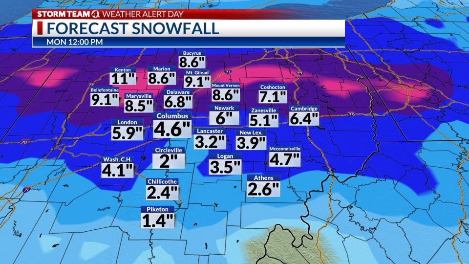
Looking ahead at the next 3 day forecast for snowfall (pictured above), not including rain, tamped down snow, or any melting (so while this might be the total that falls, you may not be able to measure this much by late Monday).
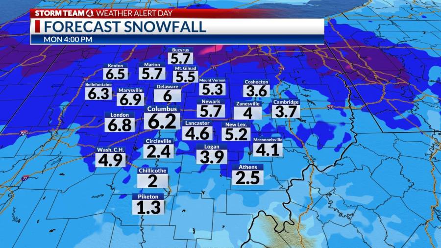
This map shows total snowfall through Monday evening.
The track of this low will most likely have some shifts over the next 36 hours and some minor adjustments to timing and number will be made.
-Dave


