WASHINGTON (WCMH/AP) — Much of the U.S. should expect another warm winter, but not quite as toasty as the last two years, forecasters say.
The National Oceanic and Atmospheric Administration on Thursday forecast a warmer winter from California through the Midwest to Maine. A colder than normal winter is predicted for southern Alaska, the Pacific Northwest and the Northern Tier states. Normal temperatures are forecast for a thin swath of states from Indiana to Idaho.
They also said that there is a 55 to 65 percent chance of La Nina developing before winter sets in. La Nina, the flip side of El Nino, is the periodic cooling of the central Pacific Ocean that affects weather patterns around the globe.
“If La Nina conditions develop, we predict it will be weak and potentially short-lived, but it could still shape the character of the upcoming winter,” said Mike Halpert, deputy director of NOAA’s Climate Prediction Center. “Typical La Nina patterns during winter include above average precipitation and colder than average temperatures along the Northern Tier of the U.S. and below normal precipitation and drier conditions across the South.”
Mike Halpert, deputy director of NOAA’s Climate Prediction Center, said it would be surprising if this winter is as warm. Halpert said the southern U.S. is likely to be drier than normal, while the north from eastern Washington through the Great Lakes to update New York is likely to be wetter.
NOAA’s winter outlook doesn’t forecast snow or specific storms, but La Ninas tend to favor more storms coming from the west and north than from the Gulf of Mexico or the East Coast, he said.The 2017 U.S. Winter Outlook (December through February):
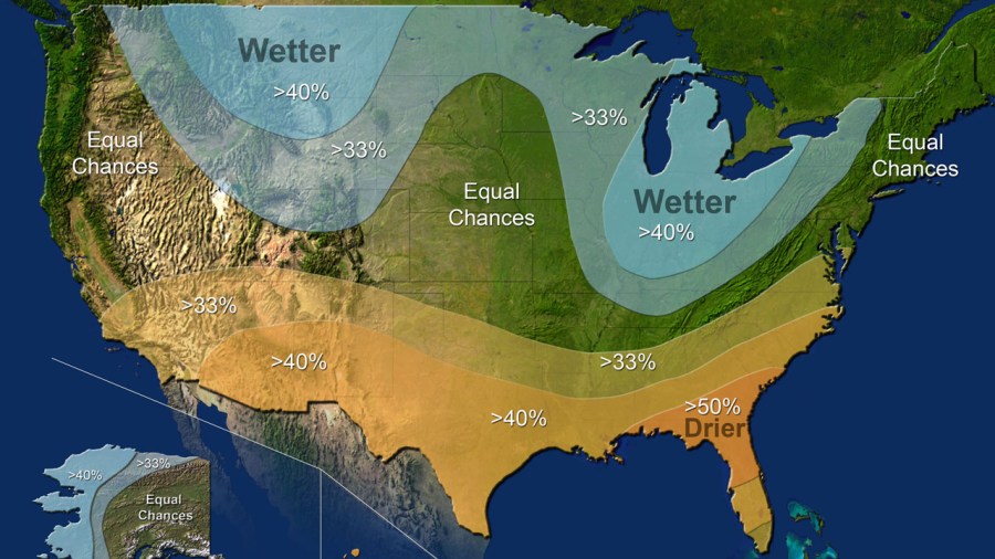
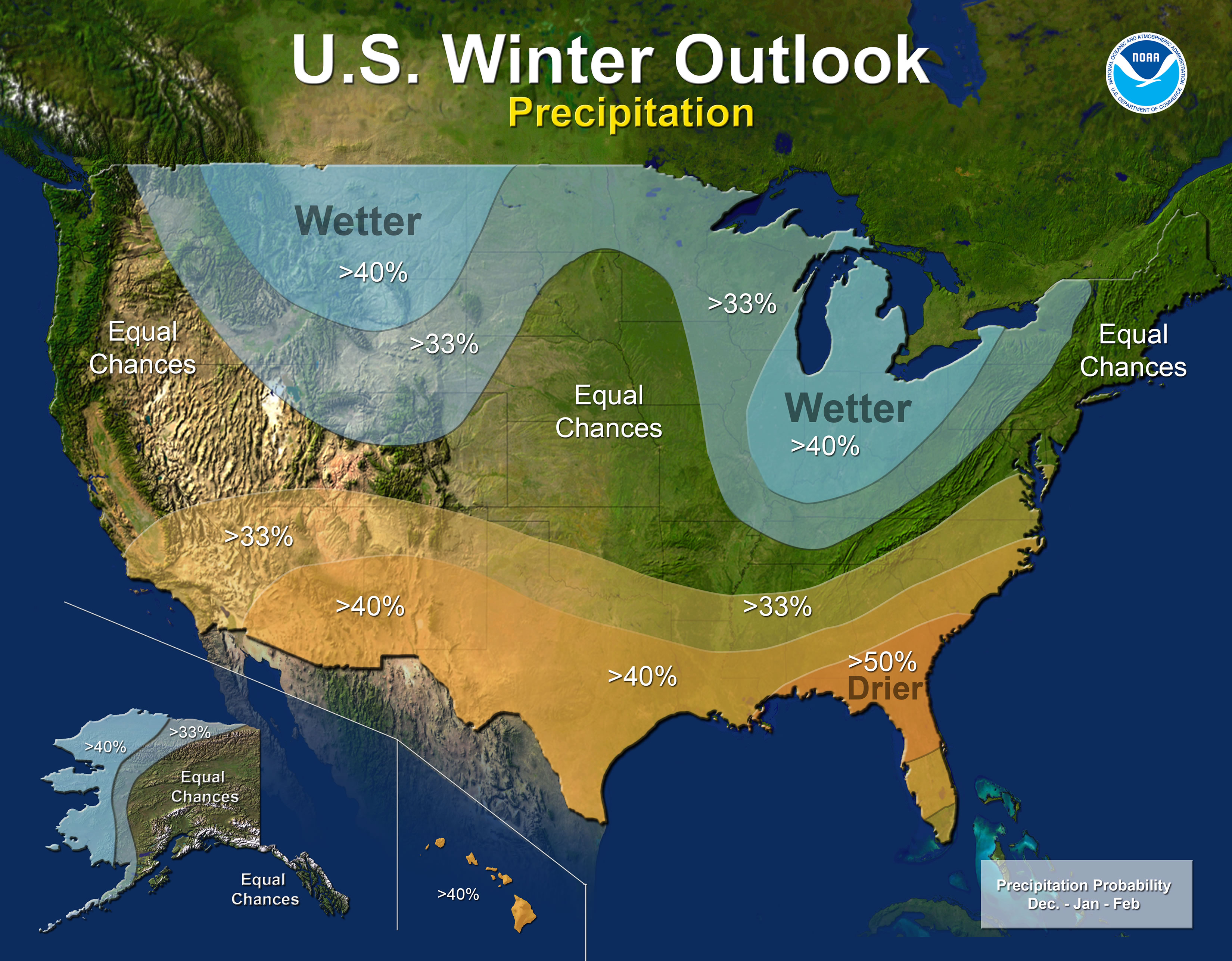
Precipitation
- Wetter-than-average conditions are favored across most of the northern United States, extending from the northern Rockies, to the eastern Great Lakes, the Ohio Valley, in Hawaii and in western and northern Alaska.
- Drier-than-normal conditions are most likely across the entire southern U.S.
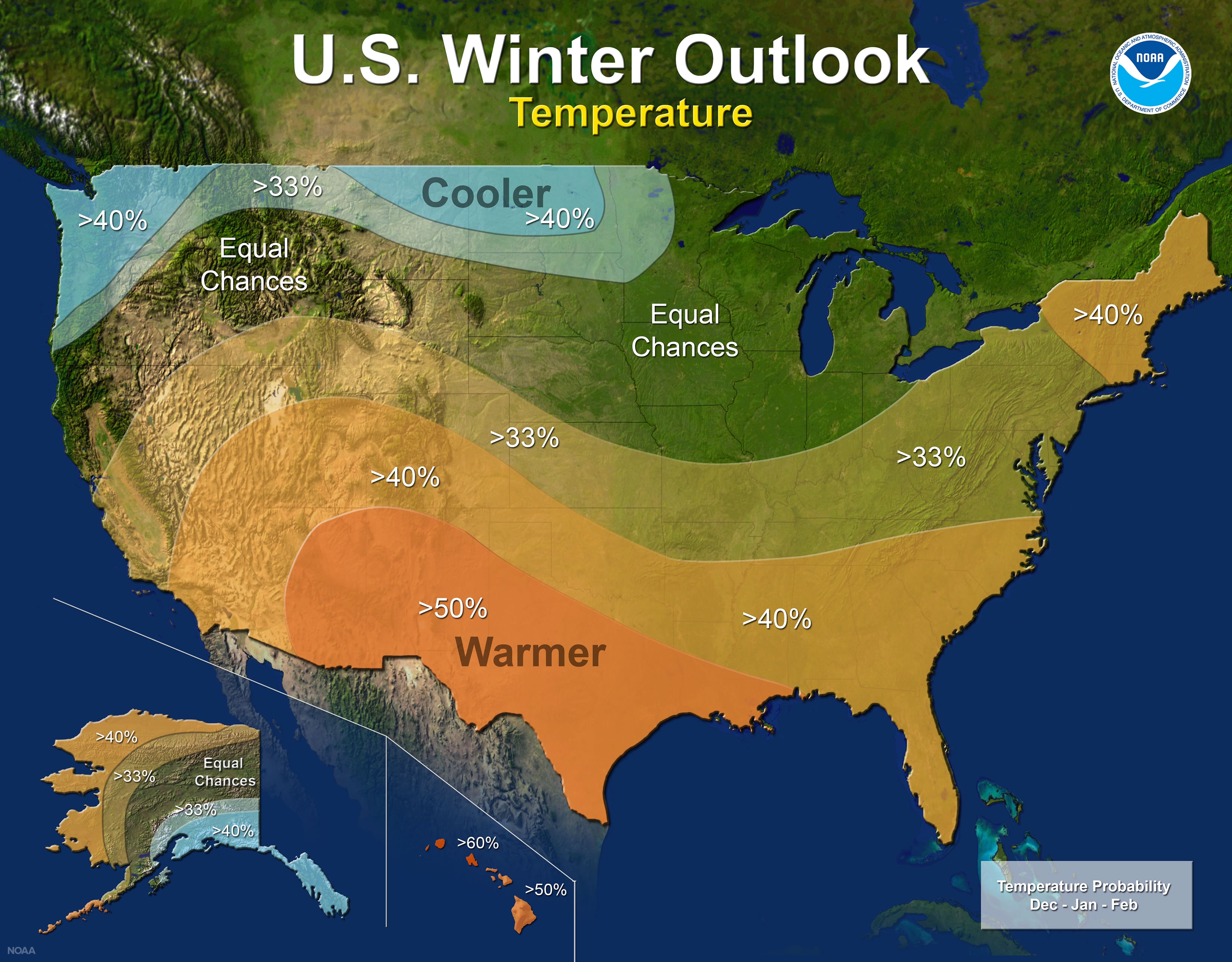
Temperature
- Warmer-than-normal conditions are most likely across the southern two-thirds of the continental U.S., along the East Coast, across Hawaii and in western and northern Alaska.
- Below-average temperatures are favored along the Northern Tier of the country from Minnesota to the Pacific Northwest and in southeastern Alaska.
- The rest of the country falls into the equal chance category, which means they have an equal chance for above-, near-, or below-normal temperatures and/or precipitation because there is not a strong enough climate signal in these areas to shift the odds.
Drought
- Despite the outlook favoring above-average precipitation this winter, drought is likely to persist in parts of the northern Plains, although improvement is anticipated farther West
- Elsewhere, drought could develop across scattered areas of the South, mainly in regions that missed the rainfall associated with the active 2017 hurricane season.
What this means for Central Ohio:
As mentioned about a month ago when a La Nina Watch was issued for this upcoming winter, it was expected to be another mild winter with lower than normal snowfall totals for our area. This can be a tricky thing to forecast on a broad scale for the state of Ohio, because of the influence of lake effect snowfall in warmer winters.
This is because, the warmer it is late in fall and early winter, we will continue to see relatively warm, and open, waters off Lake Erie and Lake Michigan. The later into winter these lakes stay open, the longer the lake effect snow season can last, and as we all know, sometimes a single lake effect snow event can produce more snow than many parts of the state can see in a season.
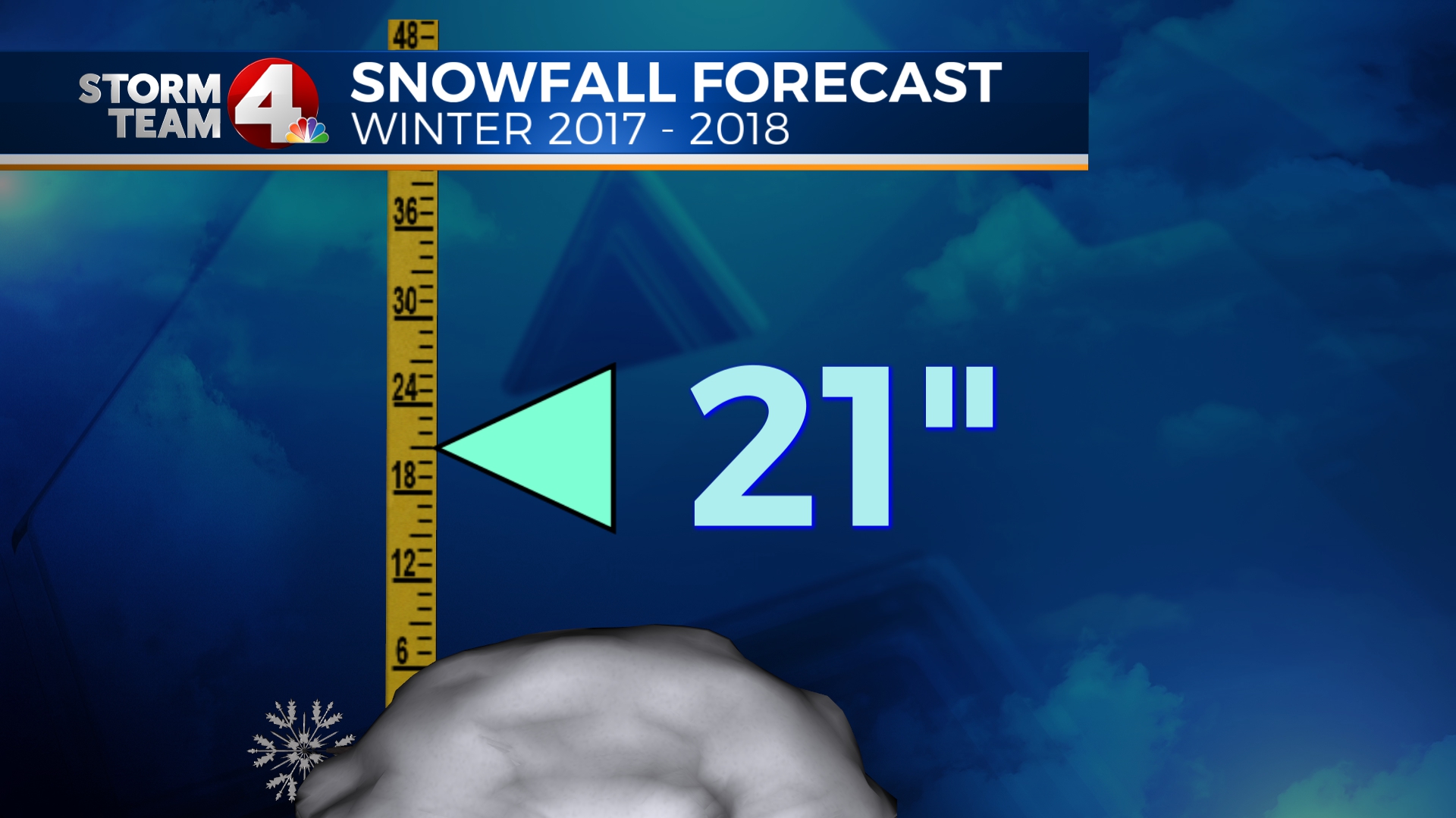
In the snowfall department, expect more than we had last year. Last year was almost a foot and a half below our normal for snowfall, and if we end up with more precipitation than normal for this upcoming winter, the odds are that a few of those clipper events are going to come across the open lakes and bring some lake effect snowfall with them.
Last year if you remember we had a mild and dry November, and December was colder with more than 5″ of snowfall, followed by some very warm (near or record warm) months to follow in the early part of this year. Our precipitation as a whole for “Meteorological Winter” (Dec-Feb) was almost normal (+0.60″). This winter appears to be trending a bit wetter, and should be a bit cooler than last year, especially later in the winter when temperatures tend to be colder and snow is easier to achieve.
At this point, expect that this will yield snowfall totals around double of last year, but still below our normal for winter. If you want to read more on the impact of an upcoming weak La Nina, and how it should impact our winter 2017-18 forecast you can check out that story here: La Nina Watch & impact on our winter snowfall