COLUMBUS, Ohio (WCMH) — An expanding pool of warmer-than-normal water in the eastern tropical Pacific Ocean confirms that El Niño is back.
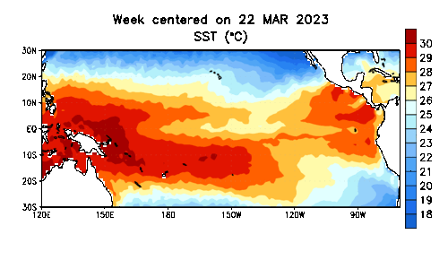
For the past several years, a rare “triple-dip” La Niña — the mirror opposite — reflected a prevailing cooling of the central and eastern tropical Pacific. Together, these two anomalous sea surface temperature patterns are referred to as El Niño-Southern Oscillation (ENSO), alternating during a 3- to 7-year cycle.
A series of relatively mild winters, followed by periodically stormy conditions in the early spring in the Midwest are a common feature of La Niña.
Ohio has already recorded 21 tornadoes since the first event on Feb. 27. Two weak EF0 storms Sunday night near Tipp City (Miami County) and Christiansburg (Champaign County) were confirmed by the National Weather Service in Wilmington.
Each climate system creates a different response in the overlying higher-level winds in the atmosphere — the jet stream and storm track — that carry low-pressure areas and moisture eastward across U.S.
The transition to an emerging El Niño initially favors a wetter pattern heading into early summer for areas recently experiencing moderate drought from the southern Plains to the Ohio Valley.
Later in the year during the fall and winter, El Niño trends drier-than-normal in the Midwest , with above-normal rainfall in the Southern states, linked to a southward shift of the upper-level winds expected in the cooler months.
The appearance of El Niño in June suggests the atmosphere will be warming, since the overlying air gathers in heat and moisture through evaporation and wind currents. The most recent strong El Niños in 2015-16 and 1997-98 brought record-breaking warm temperatures globally.
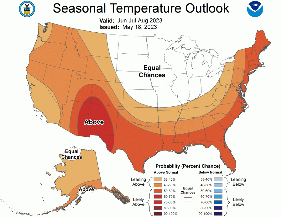
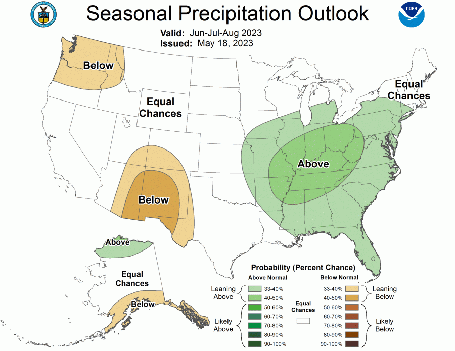
NOAA’s Climate Prediction Center is currently forecasting a hot summer across the Western and Southern states and wetter-than-average conditions in the eastern U.S., after a very dry month of May that brought record low rainfall in parts of the Mid-Atlantic.
The return of El Niño likely means fewer strong Atlantic hurricanes due to increased westerly wind shear — faster winds aloft make it more difficult for warm air to build into organized clusters of thunderstorms that turn into tropical cyclones. However, unusually warm waters in the Atlantic and Caribbean will provide extra energy for any storms that do form, so this will offset a potentially quieter tropical storm season.
Currently, NOAA forecasters are predicting a 56% chance of a strong El Niño developing and an 84% chance of at least a moderate event.