
COLUMBUS (WCMH) — An extraordinary swath of snow, ice and rain from Texas to Maine caused major travel disruptions and widespread power outages from the southern Plains to northern New England.
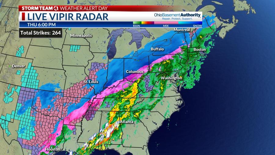
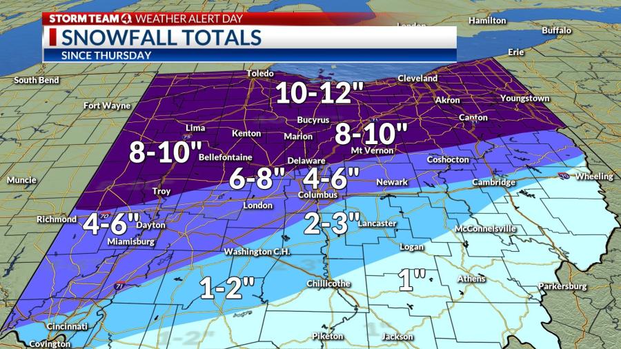
Snow accumulations of 4 to 12 inches blanketed portions of New Mexico and Colorado Wednesday, including the Denver area. Snow spread northeastward Thursday, snarling travel from Kansas City to Chicago, Indianapolis, Columbus, Cleveland and Buffalo, with accumulations of 6 to 12 inches, as a second wave of low pressure tracked from the western Gulf states to the central Appalachians.
A powerful squall line developed over Alabama south to the Gulf Coast Thursday evening along the sharp cold front, spawning a deadly tornado at Sawyerville, Alabama, where one person was killed.
Snowfall in Ohio Thursday through Friday morning was heaviest across the northern portion of the state, ranging as high as 8 to 12 inches from Bellefontaine to Mansfield, Medina and Cleveland. Accumulations along the I-70 corridor ranged from 3 to 6 inches, with a substantial accumulation of ice in southeast Ohio limiting snow totals. Winds gusted as high as 30-35 mph during the height of storm Thursday evening, causing considerable blowing and drifting.
On the edge of the arctic boundary, an ice storm left accumulations of sleet and freezing rain of a half-inch to 1 inch around Dallas, Texas, Little Rock, Arkansas, Memphis, Tennessee, Lexington, Kentucky, and a a portion southeast Ohio.
More than 300,000 lost power due to falling tree limbs bringing down power lines along the length of the storm system, including up to 76,000 customers in Ohio during the peak of the winter storm. More than 6,000 flights were cancelled due to bad weather Thursday and Friday.
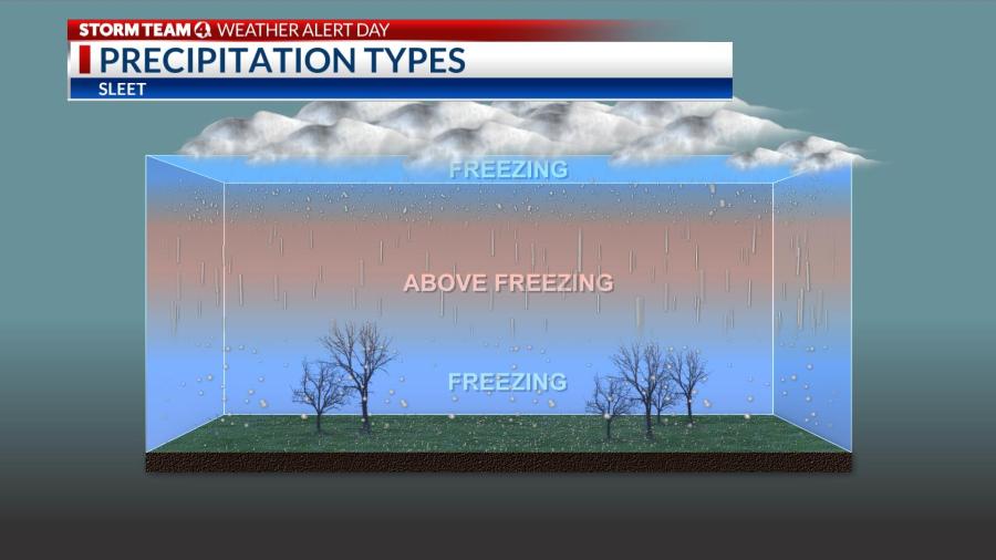
Reason For Sleet and Freezing Rain
One of the most hazardous aspects of the storm was a prolonged period of freezing rain and sleet in central Ohio that began in the Columbus area around 2 a.m. Thursday and persisted for 15 hours, even after the precipitation turned to mostly snow during the afternoon commute.
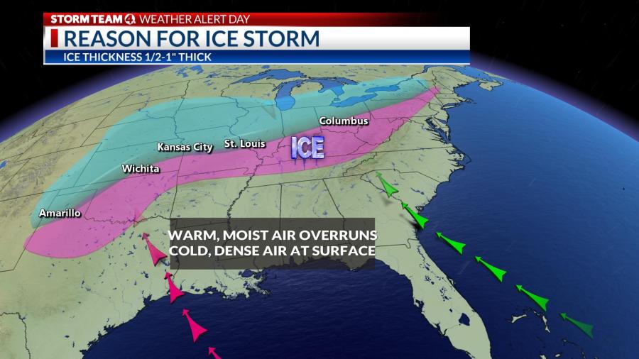
A warm “nose” became wedged above a shallow layer of arctic air near the surface that undercut the frontal boundary, causing temperatures to dip into the upper 20s. Weather balloon observations taken at the National Weather Service office in Wilmington showed temperatures still above freezing (33-34 degrees) between 4,000 and 6,000 feet aloft at 7 p.m. Thursday.
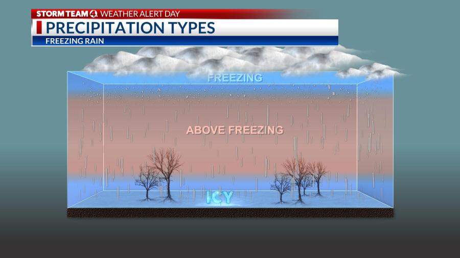
Snow aloft falling through a pocket of mild air turned to rain and promptly froze in the very shallow layer of subfreezing temperatures at the surface, forming a thick glaze on trees and power lines. Freezing rain caused treacherous travel conditions through the afternoon and evening hours.
Farther north, in Columbus and areas northwest of I-71, the warm layer not as prominent, so snow falling from a higher altitude only partially melted and then refroze, creating ice pellets or sleet that accumulated up to an inch, before a changeover to mainly snow during the evening commute.
Additional snow falling on top of a layer of ice has made travel even more difficult. Temperatures will plummet into the single digits Friday night, ensuring a refreeze of slushy patches.


