COLUMBUS, Ohio (WCMH)–The sound of tornado sirens in the predawn hours of Feb. 28 was a sign that spring storm season had arrived early. For the second year in a row, tornadoes touched down in multiple locations around central Ohio during meteorological winter (December-February).
The National Weather Service in Wilmington counted eight tornadoes that caused pockets of damage between Dayton and Newark paralleling the Interstate 70 corridor. A final tornado was confirmed in eastern Ohio in Monroe County by the Pittsburgh NWS office.
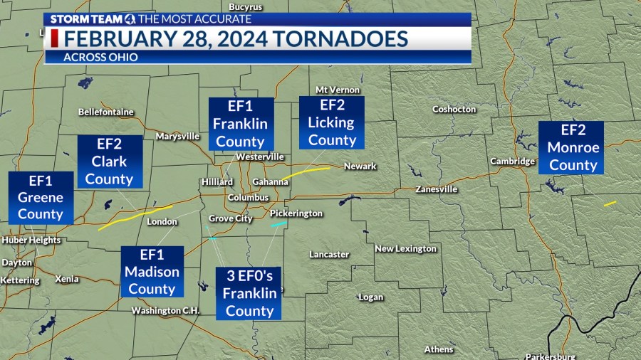
Confirmed Tornadoes on Feb. 28, 2024 (Enhanced Fujita Scale)
- Near Riverside (EF1/100 mph)
- Near Springfield (EF2/130 mph)
- East of London (EF1/110 mph)
- Hilliard (EF1/110 mph)
- West of Darbydale (EF0/70 mph)
- Near Harrisburg (EF0/70 mph)
- Near Groveport (EF0/75 mph)
- Near Jersey (EF2/120 mph)
- Near Ozark (EF2/120 mph)
Warm, moderately humid air arrived ahead of low pressure tracking from near Chicago to Lower Michigan on the night of Feb. 27-28, which added spin to an already energized atmosphere, with strong winds aloft that changed direction with height.
The unseasonably powerful line of thunderstorms evolved in a strong El Niño pattern — a warming of the eastern tropical Pacific — that typically fuels a strong subtropical jet stream and adds moisture and energy. The interaction of warm air (60s) for late February deep into the night, moisture, and a cold front that would cause the temperature to plummet more than 40 degrees in 24 hours, provided an ideal setup for severe weather.
Andrew Hatzos, a meteorologist at the NWS in Wilmington, explained why so many storms produced damage.
“We observed as many as four simultaneous circulations associated with these storms, extending from Hilliard southward to Harrisburg at about 5:30 a.m.,” he said. “At one time or another, all four of these circulations produced tornadoes.”
Hatzos pointed out that the squall line had characteristics of supercell thunderstorms that are associated with more intense rotation (mesocyclone) through the column.
“When that occurred, it resulted in the strongest tornadoes from the event — the EF2 near Springfield, and the EF2 near Blacklick/Jersey,” he said.
“Multiple circulations in similar situations have also been observed in our area in numerous other weather events, with Oct. 26, 2010 and March 1, 2017 as two examples,” Hatzso said.
The first tornado in the outbreak early Wednesday formed just south of Wright-Patterson Air Force Base, a little before 4:40 a.m., in Montgomery County northeast of Dayton, and traveled 2.4 miles into Greene County, damaging a hangar, planes going through restoration, and property around the National Museum for the U.S. Air Force.
A stronger tornado packing 130 mph winds developed four miles southeast of Springfield in Clark County and tracked 21.3 miles, lifting four miles northeast of London. The storm caused significant damage to Madison County Airport and the OSU Molly Caren Agricultural Center, between U.S. Route 40 and I-70.
Several homes had roof damage, and about a dozen barns and outbuildings were struck. Farther east, the second story of a home was destroyed. Fortunately, no injuries were reported. The path width reached 500 yards.
Another tornado was spotted a mile east of London that tracked 9.2 miles, ending two miles southeast of West Jefferson. The storms tipped a trailer, damaged the roof of a home, and snapped off tree trunks.
Two rotating thunderstorm cells spawned five tornadoes in Franklin County, including a storm that damaged several homes and a garage north of Roberts Road in Hilliard near Hilliard-Rome Road. Several weak storms touched down south of the city.

A house on Lafayette-Plain City Road near London, Ohio in Madison County takes extensive damage after a strong storm surge on February 28, 2024. (NBC4/Eric Halperin) 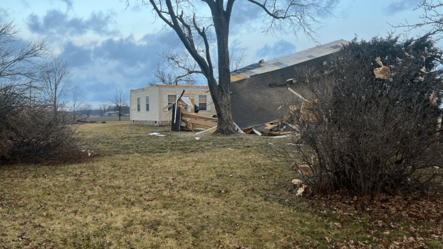
A house on Lafayette-Plain City Road near London, Ohio in Madison County takes extensive damage after a strong storm surge on February 28, 2024. (NBC4/Eric Halperin) 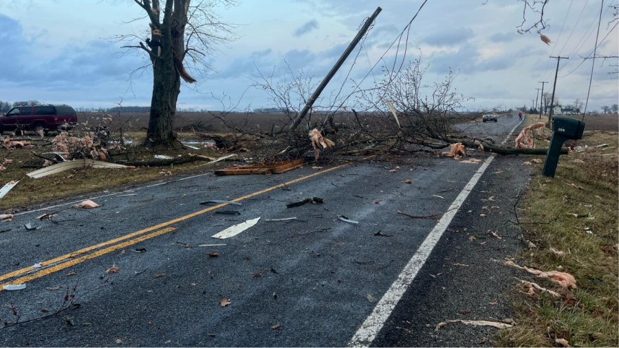
A house on Lafayette-Plain City Road near London, Ohio in Madison County takes extensive damage after a strong storm surge on February 28, 2024. (NBC4/Eric Halperin) 
A house on Lafayette-Plain City Road near London, Ohio in Madison County takes extensive damage after a strong storm surge on February 28, 2024. (NBC4/Eric Halperin) 
The Ohio State Agricultural Center in Madison County takes extensive damage after strong storms on February 28, 2024. (NBC4 Photo) 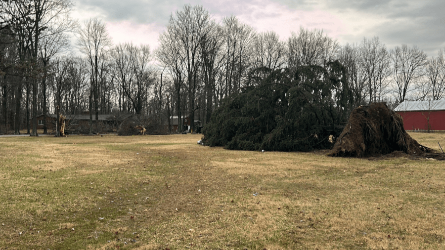
Trees are uprooted and fall on houses in Blacklick, Ohio on Belangee Road after a strong storm surge early morning on February 28, 2024. (NBC4 Photo/Delaney Ruth) 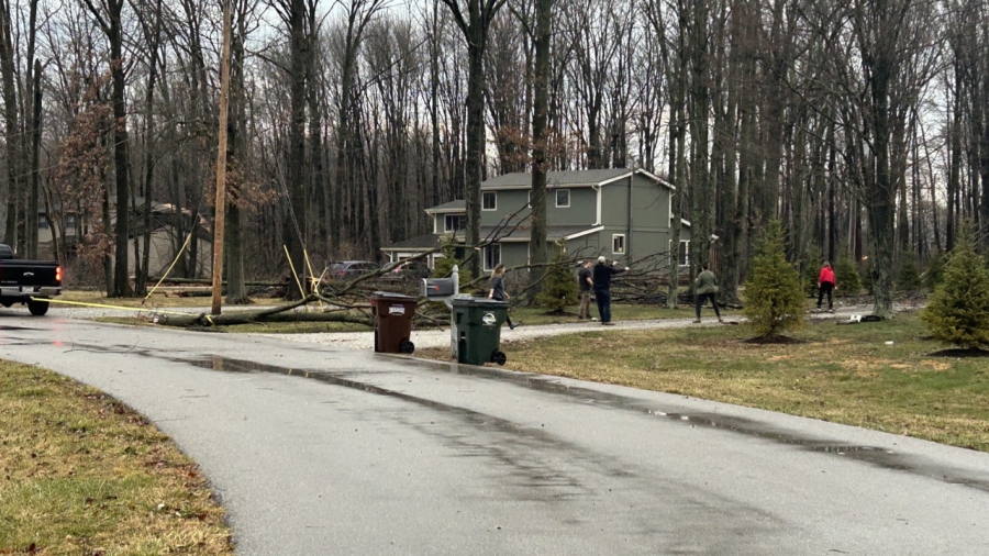
Trees are uprooted and fall on houses in Blacklick, Ohio on Belangee Road after a strong storm surge early morning on February 28, 2024. (NBC4 Photo/Delaney Ruth) 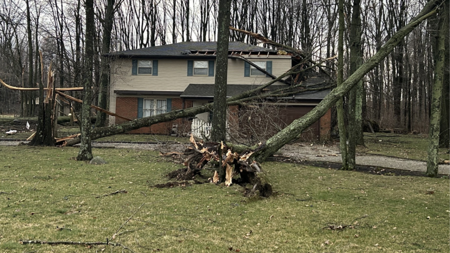
Trees are uprooted and fall on houses in Blacklick, Ohio on Belangee Road after a strong storm surge early morning on February 28, 2024. (NBC4 Photo/Delaney Ruth) 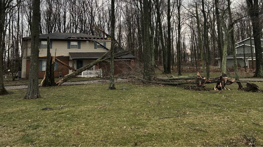
Trees are uprooted and fall on houses in Blacklick, Ohio on Belangee Road after a strong storm surge early morning on February 28, 2024. (NBC4 Photo/Delaney Ruth) 
A strong storm system brought damage to a house in Hilliard, Ohio on February 28, 2024. (NBC4 Photo/Jordyn Dunlap) 
A strong storm system brought damage to a house in Hilliard, Ohio on February 28, 2024. (NBC4 Photo/Jordyn Dunlap) 
A house in Hilliard take storm damage after a tornado warning February 28, 2024 (Courtesy Photo/Hilliard Division of Police) 
Crews clean up storm damage in Hilliard, Ohio on February 28, 2024 (Courtesy Photo/Hilliard Division of Police) 
Crews clean up storm damage in Hilliard, Ohio on February 28, 2024 (Courtesy Photo/Hilliard Division of Police) 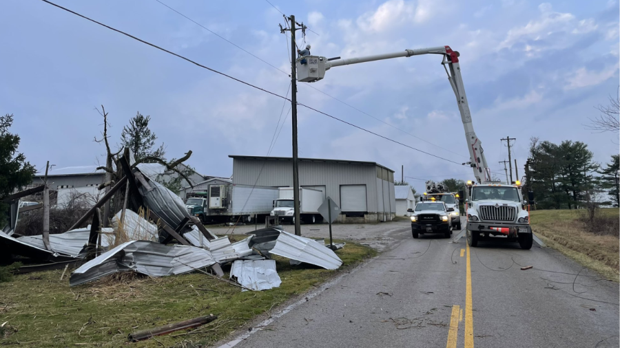
AEP Ohio crews work to restore power after storm damage in southwest Columbus, Ohio on February 28, 2024 (Courtesy Photo/AEP Ohio) 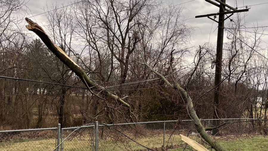
A downed trees covers a fence and power line in Lancaster, Ohio after thunderstorms on February 28, 2024 (Courtesy Photo/AEP Ohio) 
An Ohio State Highway Patrol cruiser blocks a roadway in Granville, Ohio that has multiple trees on the road after a storm surge on February 28, 2024. (Courtesy Photo/AEP Ohio) 
Multiple people shelter at John Glenn International Airport in Columbus, Ohio during tornado warning on February 28, 2024 (Courtesy Photo/Jacob Olson) 
Multiple power lines block Durrett Road in southwest Columbus after thunderstorms and a tornado warning on February 28, 2024. (Courtesy Photo/AEP Ohio) 
Storm damage at the Wright-Patterson Air Force Base in Dayton, Ohio on February 28, 2024 (Courtesy Photo/U.S. Air Force) 
Storm damage at the Wright-Patterson Air Force Base in Dayton, Ohio on February 28, 2024 (Courtesy Photo/U.S. Air Force) 
Storm damage at the Wright-Patterson Air Force Base in Dayton, Ohio on February 28, 2024 (Courtesy Photo/U.S. Air Force) 
Storm damage at the Wright-Patterson Air Force Base in Dayton, Ohio on February 28, 2024 (Courtesy Photo/U.S. Air Force) 
Storm damage at the Wright-Patterson Air Force Base in Dayton, Ohio on February 28, 2024 (Courtesy Photo/U.S. Air Force) 
Storm damage at the Wright-Patterson Air Force Base in Dayton, Ohio on February 28, 2024 (Courtesy Photo/U.S. Air Force) 
A house in West Jefferson with extensive damage after a possible tornado on February 28, 2024. (NBC4/Eric Halperin) 
A house in West Jefferson with extensive damage after a possible tornado on February 28, 2024. (NBC4/Eric Halperin) 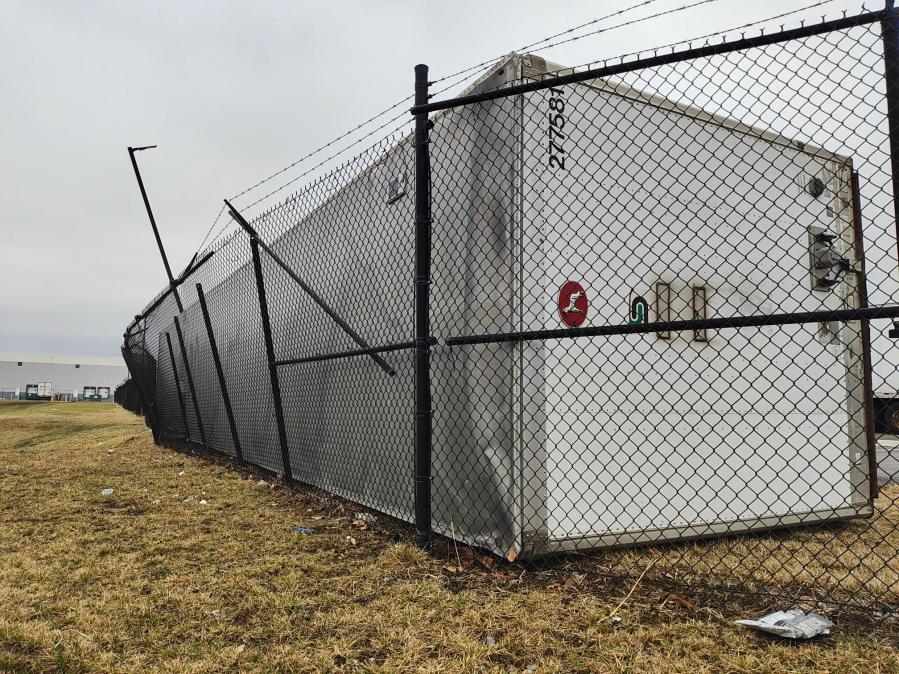
Four trailers fell against each other during Feb. 28, 2024 storms at a Groveport logistics center, overturning one and sending it smashing through the fence. (NBC4 Photo/Mark Feuerborn) 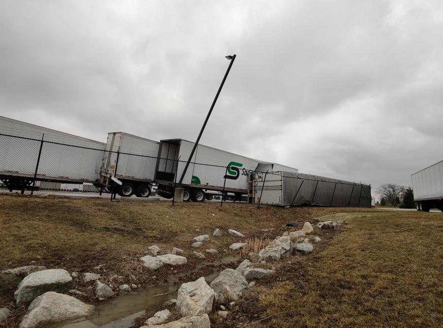
Four trailers fell against each other during Feb. 28, 2024 storms at a Groveport logistics center, overturning one and sending it smashing through the fence. (NBC4 Photo/Mark Feuerborn)
Another storm developed three miles east of Gahanna and traveled 14.1 miles to near Jersey in Licking County. One home lost a roof and exterior wall as the storm intensified, with debris strewn for hundreds of yards, before the storm crossed into Licking County. At its peak, the storm’s damage path was 300 yards wide. Numerous trees were blown down, covering roads, and a few barns were damaged or destroyed north of Pataskala.
Last year, five tornadoes were recorded in the region on Feb. 27, 2023, which had held the previous February record for tornadoes since 1950. The EF2 tornado in southeastern Franklin County was the strongest recorded in February since Feb. 22, 1971. The path length of the EF2 storms are also the longest measured in February in Ohio records since 1950.


