COLUMBUS, Ohio (WCMH) — A year ago this weekend, communities in central and northern Ohio were cleaning up following a record March tornado outbreak.
Severe thunderstorms exploded across western and central Ohio on the evening of March 14, 2024, spawning nine tornadoes, including a devastating EF3 storm that claimed three lives in Logan County near Indian Lake.
Tornadoes tear through Central Ohio
Watch a previous NBC4 report on the March 2024 thunderstorms in the video player above.
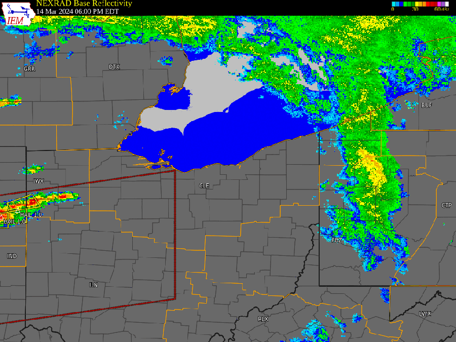
A rotating thunderstorm, or supercell, that formed in eastern Indiana triggered a family of five tornadoes that left paths of destruction from the Indiana-Ohio border to northeastern portions of the Columbus area.

The first tornado to enter Ohio on March 14, 2024, touched down in eastern Indiana at 6:40 p.m. and moved quickly into Mercer County, ending four miles west of Celina at 6:55 p.m. The tornado traveled 9.6 miles and expanded to a width of 450 yards, with 105 mph winds (EF1).
A large tornado 1,050 yards wide formed near Celina from the same parent storm minutes later at 7 p.m. and tracked into Auglaize County, rated as an EF1 (105 mph).
The most devastating storm developed around 7:30 p.m. southeast of Celina and moved into Logan County, attaining winds of 155 mph (EF3) near Orchard Island. The storm cut a deadly path through Lakeview, on south side of Indian Lake, killing three people, before lifting several miles from West Mansfield. Two hundred homes were destroyed, and 1,500 homes and businesses were damaged, according to the American Red Cross.
The same supercell spun off a tornado in southeastern Union County at 8:24 p.m. that moved to near Ostrander in Delaware County at 8:52 p.m. Winds peaked at 125 mph (EF2) along a 20-mile path. Several homes received roof damage in Union County, and a modular home was destroyed as the storm moved east after crossing Route 739. Trees were snapped or uprooted along the path.
The fifth tornado triggered by the long-lived supercell thunderstorm touched down three miles south of Delaware and traveled 35.6 miles across southern Delaware and northern Licking counties to St. Louisville, with winds 110 mph winds (EF1), and a damage path up to 600 yards.
The tornado gathered strength crossing the Olentangy River, before striking the athletic fields of Olentangy Berlin High School. Several transmission towers were damaged, and homes along the storm’s track had roof and siding damage, along with snapped and uprooted trees. The tornado crossed Alum Creek Reservoir, with tree, partial roof and window damage south of Sunbury and west of Galena.
Wind damage continued across northern Licking County, including the roofs of homes, and several barns were destroyed. Considerable tree and power pole damage was caused by a combination of tornadic and straight-line winds, according to the National Weather Service in Wilmington.
In northern Ohio, an EF1 tornado (100 mph winds) hit Orange Township in southwestern Hancock County at about 7:30 p.m., the second storm to touch down in the county, and tracked 3.35 miles, damaging a few homes homes and outbuildings.
An EF2 tornado developed next in Crawford County a little before 8 p.m. and traveled for more than 1o miles into Richland County, “damaging multiple residences and outbuildings,” according to the National Weather Service office in Cleveland.
Record tornado year in Ohio
By the end of the year, a record total of 74 tornadoes had touched down in Ohio. The first outbreak of the season spawned nine tornadoes on Feb. 28, 2024. The final touchdown was a weak storm in Union County on Dec. 29.
You can keep track of the latest Storm Team 4 forecast by downloading our free Storm Team 4 Weather app and NBC4 Columbus mobile app.


