COLUMBUS, Ohio (WCMH) — Summer officially arrived at 10.57 a.m. Eastern time on Wednesday, when the sun reached its highest elevation in the sky in the Northern Hemisphere–the longest day of the year everywhere north of the Tropic of Cancer (23.5 degrees north latitude).
Daylight lingers for a little more than 15 hours this week in central Ohio: The sun rose at 6:03 this morning and sets at 9:04 tonight.
The average high temperature reaches 84 degrees to mark the start of astronomical summer. Yet we have only experienced two days of 80-degree weather in Columbus since June 11.
Last week an unseasonal deep dip in the jet stream, and associated low pressure, brought several periods of heavy rain and an outbreak of nine tornadoes in northern Ohio, after nearly a month of dry weather with spotty showers.
Two to six inches of rain fell from June 11 to 16 in central Ohio, eliminating a developing moderate drought, while also keeping temperatures on the cool side due to persistent cloud cover.
The sun finally returned after two more days of clouds and occasional showers that kept temperatures in check, in the low to mid-70s. The reason is an unusually strong upper-level storm over the Southeast that has essentially stalled, and is about to move north again, bringing clouds, cooler weather and showers the next few days.
The weather pattern has been very stormy unusually far south this week. More than 10 inches of rain fell in southern Alabama on Monday, and 6-12 inches poured down in spots between Greenville, South Carolina, and Charlotte, North Carolina, closing dozens of roads due to flooding.
The jet stream is the atmospheric traffic controller, with cooler conditions to the north and warmer weather south of the corridor of winds aloft.
In recent weeks, an uncommon northerly circulation over the Midwest due to a blocking pattern featuring low pressure over New England, transported wildfire smoke from eastern Canada into Ohio, making skies hazy with glowing reddish-orange sunsets.

Although natural variability is behind the contorted circulation, there is another player that recently took the field.
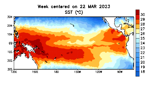
A developing El Niño — warmer-than-average oceanic surface temperatures in the equatorial Pacific — is likely responsible for an amplified southern, or subtropical jet stream that has been feeding rounds of intense thunderstorms, with large hail, torrential rain and tornadoes, from the central Plains to the Southeast and north to the Mid-Atlantic.
Last Thursday, a deadly EF3 tornado took three lives and damaged nearly 200 homes in Terryton, Texas, near the Oklahoma border, and intense rainfall in excess of a foot swamped parts of the Florida Panhandle.
Jet stream energy interacting with tropical moisture spawned more severe storms over the weekend that raked communities from the central Plains to the Gulf states. Winds gusted to 100 mph at Tulsa, Oklahoma, shortly before midnight on Saturday, knocking down trees and causing thousands to lose power.
Deadly tornadoes struck in central Mississippi and the Florida Panhandle late Sunday night and Monday. More than 100 structures were damaged or destroyed in Louin, Mississippi. Hundreds of thousands of people were without power following multiple rounds of powerful, soaking storms from northern Texas to the Gulf Coast.
South of the jet stream, blistering heat developed over South Texas late last week, as temperatures soared to 110 degrees, with a heat index topping 120.
The heat dome expanded this week. The thermometer reached 116 degrees in Cotulla, and 115 at Laredo, Texas, on Monday, tying the all-time record. San Angelo hit an all-time high of 114 on Tuesday.
The stifling conditions (100-110 degrees) combined with high humidity are bringing heat indices of 115-120 degrees to the Lone Star State.
Heading into the summer, NOAA’s Climate Prediction Center outlook called for hotter-than-normal weather in the West and South and above-normal precipitation in most of the East, including the Ohio Valley.
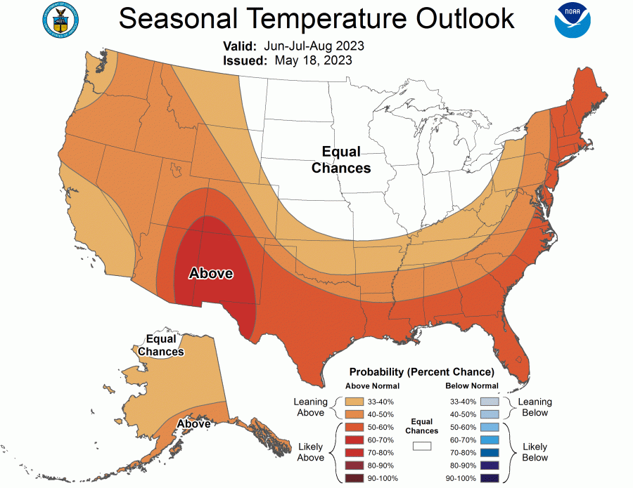
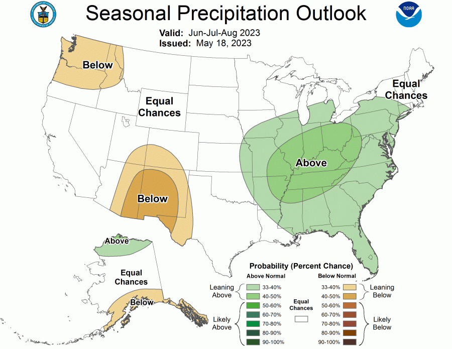
A recently updated outlook for the latter half of summer is projecting a shift to above-normal temperatures and near-normal moisture in the Ohio Valley.
Regardless, it’s now officially astronomical summer, whatever the weather holds!


